File:Niederleschen. Ortsplan nach 1823.jpg

Size of this preview: 435 × 599 pixels. Other resolutions: 174 × 240 pixels | 348 × 480 pixels | 557 × 768 pixels | 743 × 1,024 pixels | 1,486 × 2,048 pixels | 2,797 × 3,854 pixels.
Original file (2,797 × 3,854 pixels, file size: 2.83 MB, MIME type: image/jpeg)
Captions
Captions
Add a one-line explanation of what this file represents
Summary
edit
| Description |
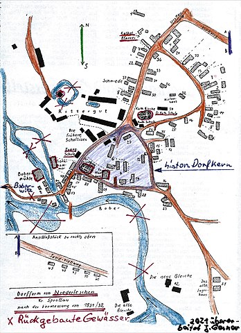
Deutsch: Niederleschen, Ortsplan nach der Vermessung um 1832. Mit Einbesserungen der rückgebauten Gewässer und Brücken |
| Date | |
| Source |
Own work based on: Steller, Georg (1960). "Bauerngüter und Gärtnerstellen in Niederleschen". Sagan-Sprottauer Heimatbrief: 17. ({{PD-simple}}, {{PD-GermanGov}}) |
| Author | Georg Steller, aktuelle Korrektur des Dorfbildes 16Exul82, alias Jürgen Gerner |
Licensing
edit
| This image of simple geometry is ineligible for copyright and therefore in the public domain, because it consists entirely of information that is common property and contains no original authorship. |  |
File history
Click on a date/time to view the file as it appeared at that time.
| Date/Time | Thumbnail | Dimensions | User | Comment | |
|---|---|---|---|---|---|
| current | 20:01, 27 July 2021 | | 2,797 × 3,854 (2.83 MB) | 16Exul82 (talk | contribs) | Cross-wiki upload from de.wikipedia.org |
You cannot overwrite this file.
File usage on Commons
There are no pages that use this file.
File usage on other wikis
The following other wikis use this file:
- Usage on de.wikipedia.org