File:Niger ag land use map USGS.png
No higher resolution available.
Niger_ag_land_use_map_USGS.png (800 × 267 pixels, file size: 131 KB, MIME type: image/png)
Captions
Captions
Add a one-line explanation of what this file represents
Summary edit
| Description |
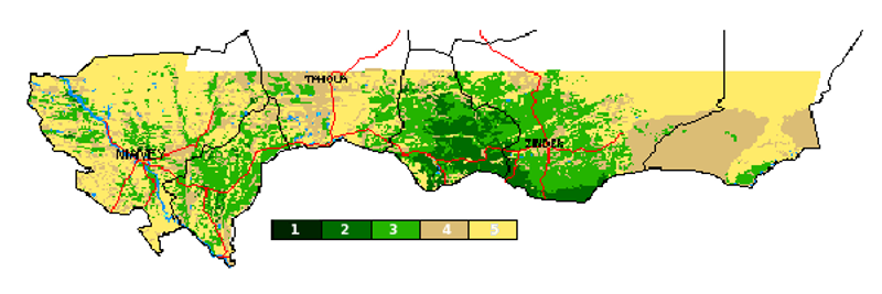
English: Niger, Cropland Use Indicator, drawn from Normalized Difference Vegetation Index (NDVI) data, for period 1986-1988. Scale is:
1= 70% - 100% Crop coverage 2= 50% - 70% Crop coverage 3= 30% - 50% Crop coverage 4= 5% - 30% Crop coverage 5= 0% - 5% Crop coverage Covering southern (Sahelian) Niger. Only cropland excluded would be highly localized oasis and Air Mountain farming in the north of the country. "METADATA FOR Niger, Cropland Use
   Publication_Date: 1986-1988
   Title: Landsat 1, 2, 4 MSS Composite
   Geospatial_Data_Presentation_Form: map
   Series_Information:
   Publication_Information:
     Publication_Place: Sioux Falls, SD, USA
     Publisher: EDC
   Other_Citation_Details: Scale - 1:200,000 / 20 sheets
   Online_Linkage:
   Larger_Work_Citation:
   Scale_Denominator: 200,000

 Description:
   Abstract:
   This coverage was created to allow for the accumulation
   and graphic presentation of data linked to cropped lands
   in the African country of Niger.

   Niger is associated with the Sahel Region.


   Keywords:
   CUI, Crop Use Intensity, Niger, NG, Africa, Sahel region.


   Purpose:
   This data set was developed as a tool and is to be used
   to monitor crop conditions and crop production.  It was
   designed to be used in conjunction with Normalized
   Difference Vegetation Index (NDVI) data.  In addition,
   the data may be used to disaggregate agricultural and/or
   population statistics spatially.


   Supplemental_Information:

     Procedures_Used:
     The agricultural overlay was prepared through interpretation
     of Landsat 5 Mulitspectral Scanner (MSS).  Landsat MSS bands
     1, 2 and 4, corresponding to multispectral bands green, red
     and near infra-red, are represented by the primary colors
     blue, green and red respectively (standard false-color composite).

     The data is subjectively based upon the interpreters
     knowledge and ancillary data.  The data lacks complete
     ground truth by field checking.


     Revisions:
     This data set has been altered to conform to the standard boundary
     file chosen for Niger, Africa.  The ARC IDENTITY utility was
     used to conform the CUI data set to the country's ADMIN1 boundary.
     file.  The resulting file was then processed to eliminate un-labeled
     polygons along the international boundary using the ARC ELIMINATE
     command.


     Reviews_Applied_to_Data:


     Related_Spatial_and_Tabular_Data_Sets:


     Other_References_Cited:
     United States Geological Survey (USGS)/EROS Data Center (EDC),
     "Landsat MSS Composite."  EDC, Sioux Falls, SD, USA.  1986-1988.
     20 map sheets.  Scale - 1:200,000.

     USGS/EDC,  "Niger Crop Use Intensity,"  Series: CUI.  EDC, Sioux
     Falls, SD, USA.  August 13, 1992.  Scale - 1:250,000.

     USGS/EDC,  "MSS Imagery."  EDC, Sioux Falls, SD, USA.
     Scale - 1:250,000.

     Environmental Systems Research Institute (ESRI),  "Digital
     Chart of the World,"  Series:  International Boundary.  ESRI,
     Redlands, CA, USA.  1992.  Scale - 1:1.000.000.


     Notes:


 Time_Period_of_Content:
   Range_of_Dates/Times:
   Currentness_Reference:
   The MSS Imagery was from 1986-1988.  The development of this
   data set was August 13, 1992.
" Metadata available at http://earlywarning.usgs.gov/ftp2/vector/cuil/ngcuil.html Image available at USGS data site:http://earlywarning.usgs.gov/adds/geodatas1.php?area=ng |
| Date | |
| Source | http://igskmncnwb015.cr.usgs.gov/ftp2/vector/cuil/ngcuil.gif |
| Author | United States Geological Survey |
Licensing edit
This image is in the public domain in the United States because it only contains materials that originally came from the United States Geological Survey, an agency of the United States Department of the Interior. For more information, see the official USGS copyright policy.
|
File history
Click on a date/time to view the file as it appeared at that time.
| Date/Time | Thumbnail | Dimensions | User | Comment | |
|---|---|---|---|---|---|
| current | 17:13, 26 February 2009 | 800 × 267 (131 KB) | T L Miles (talk | contribs) | {{Information |Description={{en|1=Niger, Cropland Use Indicator, drawn from Normalized Difference Vegetation Index (NDVI) data, for period 1986-1988. Scale is: 1= 70% - 100% Crop coverage 2= 50% - 70% Crop coverage 3= 30% - 50% Crop coverage 4= 5% - 30% C |
You cannot overwrite this file.
File usage on Commons
There are no pages that use this file.
File usage on other wikis
The following other wikis use this file:
- Usage on en.wikipedia.org