File:Noeufossé mai 2001.jpg
No higher resolution available.
Noeufossé_mai_2001.jpg (567 × 363 pixels, file size: 86 KB, MIME type: image/jpeg)
Captions
Captions
Add a one-line explanation of what this file represents
Summary
edit
| Description |
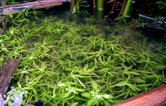
Français : Réapparition d'une flore aquatique plus normale (ici : callitriche sp.), dans le lagunage mis en place lors d'une Expérience-test de corridor biologique à vocation de lagunage naturel linéaire, le long du chemin de halage (Lieu dit Pont Asquin, rive droite) Le . C'est une Collaboration VNF-Agriculteur local-Nord Nature, Conseil Régional, qui a été un succès avant d'être rasé et comblé par erreur par une entreprise chargée de l'entretien du chemin, puis dégradé par un apport de déchets industriels sur le chemin. Canal de Noeufossé, de Neufossé ou Canal du Bassin minier est sur une grande partie de son tracé un cours d'eau totalement artificiel (et non une rivière qui a été canalisée) Il a originellement été créé non pas d'abord pour relier le fleuve côtier de l'Aa du Pas de Calais à la rivière de la Lys (dans le nord), entre les communes de Saint-Omer et d'Aire-sur-la-Lys, mais pour des raisons de stratégie militaire défensive, peu après l'an 1000. Il constitue la plus grande partie du Canal Dunkerque-Escaut. |
| Date | |
| Source | Own work |
| Author | Lamiot |
Licensing
edit
I, the copyright holder of this work, hereby publish it under the following licenses:

|
Permission is granted to copy, distribute and/or modify this document under the terms of the GNU Free Documentation License, Version 1.2 or any later version published by the Free Software Foundation; with no Invariant Sections, no Front-Cover Texts, and no Back-Cover Texts. A copy of the license is included in the section entitled GNU Free Documentation License. |
This file is licensed under the Creative Commons Attribution-Share Alike 3.0 Unported, 2.5 Generic, 2.0 Generic and 1.0 Generic license.
- You are free:
- to share – to copy, distribute and transmit the work
- to remix – to adapt the work
- Under the following conditions:
- attribution – You must give appropriate credit, provide a link to the license, and indicate if changes were made. You may do so in any reasonable manner, but not in any way that suggests the licensor endorses you or your use.
- share alike – If you remix, transform, or build upon the material, you must distribute your contributions under the same or compatible license as the original.
You may select the license of your choice.
File history
Click on a date/time to view the file as it appeared at that time.
| Date/Time | Thumbnail | Dimensions | User | Comment | |
|---|---|---|---|---|---|
| current | 16:16, 17 February 2008 | | 567 × 363 (86 KB) | Lamiot (talk | contribs) | {{Information |Description= {{fr}} Réapparition d'une flore aquatique plus normale, dans le lagunage mis en place lors d'une Expérience-test de corridor biologique à vocation de lagunage naturel linéaire, le long du chemin de halage (Lieu dit |
You cannot overwrite this file.
File usage on Commons
There are no pages that use this file.