File:Noord-Holland gemeenten 2017.png

Size of this preview: 322 × 600 pixels. Other resolutions: 129 × 240 pixels | 258 × 480 pixels | 412 × 768 pixels | 1,174 × 2,186 pixels.
Original file (1,174 × 2,186 pixels, file size: 178 KB, MIME type: image/png)
Captions
Captions
Add a one-line explanation of what this file represents
Summary edit
| Description |
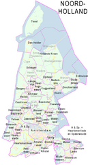
Nederlands: Provincie Noord-Holland, met indeling van gemeenten (2010).
Door Jan-Willem van Aalst, samengesteld uit publiek beschikbare geo-data:
|
| Date | 2010-01-01, actualized & re-texted 2018-05-29 |
| Source | File:2010-P07-Noord-Holland-outline-tr.png |
| Author | Janwillemvanaalst, re-texted by Ulamm (talk) |
| Other versions | see source |
Licensing edit
I, the copyright holder of this work, hereby publish it under the following license:
This file is licensed under the Creative Commons Attribution-Share Alike 3.0 Unported license.
- You are free:
- to share – to copy, distribute and transmit the work
- to remix – to adapt the work
- Under the following conditions:
- attribution – You must give appropriate credit, provide a link to the license, and indicate if changes were made. You may do so in any reasonable manner, but not in any way that suggests the licensor endorses you or your use.
- share alike – If you remix, transform, or build upon the material, you must distribute your contributions under the same or compatible license as the original.
File history
Click on a date/time to view the file as it appeared at that time.
| Date/Time | Thumbnail | Dimensions | User | Comment | |
|---|---|---|---|---|---|
| current | 11:42, 28 August 2018 | | 1,174 × 2,186 (178 KB) | Ulamm (talk | contribs) | more fusions since 2010 |
| 11:13, 29 May 2018 |  | 1,174 × 2,186 (178 KB) | Ulamm (talk | contribs) | {{Information |Description={{nl|1=Provincie Noord-Holland, met indeling van gemeenten (2010). Door Jan-Willem van Aalst, samengesteld uit publiek beschikbare geo-data: * Referentie-ondergrond (kustlijn, steden, wegen) gerasterd uit de OpenStreet Map OSM. (http://www.openstreetmap.org/index.html) Inhoud is beschikbaar onder de Creative Commons Attribution-ShareAlike 3.0 license. * Vectorgrenzen van gemeenten en regio's vrij ter beschikking gesteld met dank aan cartografen van brandweerregio's ... |
You cannot overwrite this file.
File usage on Commons
The following page uses this file:
File usage on other wikis
The following other wikis use this file: