File:Nora (LANDSAT).png

Size of this preview: 551 × 599 pixels. Other resolutions: 221 × 240 pixels | 441 × 480 pixels | 878 × 955 pixels.
Original file (878 × 955 pixels, file size: 1.04 MB, MIME type: image/png)
Captions
Captions
Add a one-line explanation of what this file represents
Summary
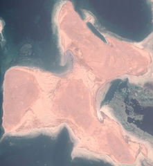
edit| Description |
Deutsch: Landsat-Bild von Nora (Norah)
English: Satellite image of Nora (not Nahaleg!) |
|||
| Date | ||||
| Source |
NASA World Wind, OnEarth WMS Global Mosaic visual color layer. Coordinates: |
|||
| Author | NASA World Wind | |||
| Permission (Reusing this file) |
|

.png&action=edit§ion=1)
File history
Click on a date/time to view the file as it appeared at that time.
| Date/Time | Thumbnail | Dimensions | User | Comment | |
|---|---|---|---|---|---|
| current | 19:26, 19 November 2006 | | 878 × 955 (1.04 MB) | Hautala (talk | contribs) | cropped |
| 18:47, 19 November 2006 |  | 1,280 × 974 (1.56 MB) | Hautala (talk | contribs) | {{PD-WorldWind}} Satellite image of Nagaleg. Image captured from NASA World Wind, OnEarth WMS visual color layer. Coordinates: worldwind://goto/world=Earth&lat=16.04546&lon=40.06094&alt=19851 Category:Red Sea [[Category:Satellite images of islands |
You cannot overwrite this file.
File usage on Commons
The following 2 pages use this file:
- File:Nahaleg OnEarth.png (file redirect)
- File:View of Nahaleg from space.png (file redirect)
File usage on other wikis
The following other wikis use this file:
- Usage on ar.wikipedia.org
- Usage on arz.wikipedia.org
- Usage on az.wikipedia.org
- Usage on ceb.wikipedia.org
- Usage on de.wikipedia.org
- Usage on en.wikipedia.org
- Usage on es.wikipedia.org
- Usage on fi.wikipedia.org
- Usage on ka.wikipedia.org
- Usage on nl.wikipedia.org
- Usage on pl.wikipedia.org
- Usage on pt.wikipedia.org
- Usage on ru.wikipedia.org
- Usage on uk.wikipedia.org
- Usage on www.wikidata.org
.png&oldid=487132848)