File:Nord-Trondelag Municipalities.png

Size of this preview: 800 × 487 pixels. Other resolutions: 320 × 195 pixels | 640 × 390 pixels | 1,025 × 624 pixels.
Original file (1,025 × 624 pixels, file size: 24 KB, MIME type: image/png)
Captions
Captions
Add a one-line explanation of what this file represents

|
File:Kommuner i Nord-Trøndelag.svg is a vector version of this file. It should be used in place of this PNG file when not inferior.
File:Nord-Trondelag Municipalities.png → File:Kommuner i Nord-Trøndelag.svg
For more information, see Help:SVG. |
 |
Summary edit
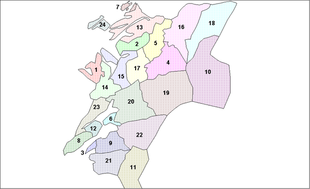
Map of the municipalities of Nord-Trondelag County in Norway. Created by Rarelibra for public domain use. Created using MapInfo Professional v7.5 and various mapping resources.
This map is now incorrect. As of 1.1.2012 Mosvik and Inderøy municipalities merged. Use the SVG file listed above instead.
Licensing edit
| This work has been released into the public domain by its author, I, Rarelibra. This applies worldwide. In some countries this may not be legally possible; if so: I, Rarelibra grants anyone the right to use this work for any purpose, without any conditions, unless such conditions are required by law. |
File history
Click on a date/time to view the file as it appeared at that time.
| Date/Time | Thumbnail | Dimensions | User | Comment | |
|---|---|---|---|---|---|
| current | 21:21, 3 August 2007 | | 1,025 × 624 (24 KB) | Rarelibra (talk | contribs) | Map of the municipalities of Nord-Trondelag County in Norway. Created by Rarelibra for public domain use. Created using MapInfo Professional v7.5 and various mapping resources. |
You cannot overwrite this file.
File usage on Commons
The following page uses this file:
File usage on other wikis
The following other wikis use this file:
- Usage on bat-smg.wikipedia.org
- Usage on ca.wikipedia.org
- Usage on da.wikipedia.org
- Usage on eo.wikipedia.org
- Usage on et.wikipedia.org
- Usage on eu.wikipedia.org
- Usage on fr.wikipedia.org
- Usage on hr.wikipedia.org
- Usage on hu.wikipedia.org
- Usage on id.wikipedia.org
- Usage on ja.wikipedia.org
- Usage on ka.wikipedia.org
- Usage on ko.wikipedia.org
- Usage on pl.wikipedia.org
- Usage on ro.wikipedia.org
- Usage on ru.wikipedia.org
- Usage on sw.wikipedia.org
- Usage on zh.wikipedia.org