File:Norra Vanga med Lumbers hog 20180627.jpg

Size of this preview: 800 × 450 pixels. Other resolutions: 320 × 180 pixels | 640 × 360 pixels | 1,024 × 576 pixels | 1,280 × 720 pixels | 2,560 × 1,440 pixels | 5,472 × 3,078 pixels.
Original file (5,472 × 3,078 pixels, file size: 6.84 MB, MIME type: image/jpeg)
Captions
Captions
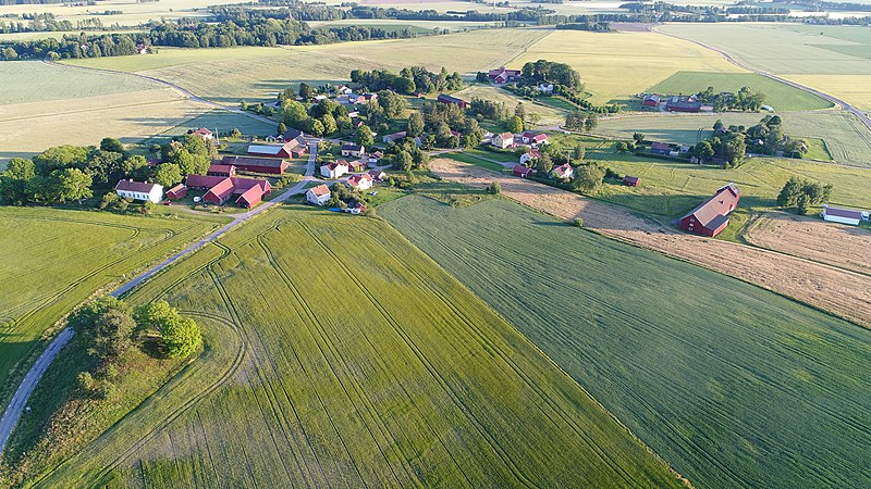
Norra Vånga village in Sweden, view from north-east.
Summary
edit
| Description |
Svenska: Norra Vånga by i Västergötland med Lagman Lumbers hög i förgrunden och kyrkan i bakgrunden
English: Norra Vånga village in Västergötland, Sweden, with Lumbers' tumulus in the foreground and the church in the background. |
| Date | |
| Source | Own work |
| Author | Joel Grafström |
| Camera location | | View this and other nearby images on: OpenStreetMap |
|---|

|
This aerial photograph has been approved for publishing by the Swedish National Land Survey with the ID: LM -2019/007692
|
Licensing
edit
I, the copyright holder of this work, hereby publish it under the following license:
This file is licensed under the Creative Commons Attribution-Share Alike 4.0 International license.
- You are free:
- to share – to copy, distribute and transmit the work
- to remix – to adapt the work
- Under the following conditions:
- attribution – You must give appropriate credit, provide a link to the license, and indicate if changes were made. You may do so in any reasonable manner, but not in any way that suggests the licensor endorses you or your use.
- share alike – If you remix, transform, or build upon the material, you must distribute your contributions under the same or compatible license as the original.
| Annotations | This image is annotated: View the annotations at Commons |
File history
Click on a date/time to view the file as it appeared at that time.
| Date/Time | Thumbnail | Dimensions | User | Comment | |
|---|---|---|---|---|---|
| current | 10:55, 31 May 2019 | | 5,472 × 3,078 (6.84 MB) | Leojth (talk | contribs) | User created page with UploadWizard |
You cannot overwrite this file.
File usage on Commons
There are no pages that use this file.
File usage on other wikis
The following other wikis use this file:
- Usage on sv.wikipedia.org
- Usage on www.wikidata.org