File:North West Point, Lundy - geograph.org.uk - 545747.jpg
No higher resolution available.
North_West_Point,_Lundy_-_geograph.org.uk_-_545747.jpg (640 × 480 pixels, file size: 102 KB, MIME type: image/jpeg)
Captions
Captions
Add a one-line explanation of what this file represents
Summary
edit
| Description |
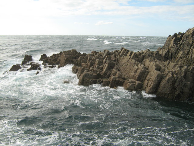
English: North West Point, Lundy Taken from the very NW tip of Lundy [just in the square], showing an off-shore rock [the gap is a very scary 3 yards of white water!]. The rough sea beyond is a tide rip caused by the flood tide going north east over rocks, and meeting a strong north easterly wind trying to push it back. It would be an unpleasant place to sail in these conditions [regardless of the submarine rocks!]. The point is reached by scrambling down below the North Light. |
| Date | |
| Source | From geograph.org.uk |
| Author | David Medcalf |
| Attribution (required by the license) | David Medcalf / North West Point, Lundy / |
| Camera location | | View this and other nearby images on: OpenStreetMap |
|---|
_heading:292.00&language=en)
| Object location | | View this and other nearby images on: OpenStreetMap |
|---|
_heading:292.00&language=en)
Licensing
edit

|
This image was taken from the Geograph project collection. See this photograph's page on the Geograph website for the photographer's contact details. The copyright on this image is owned by David Medcalf and is licensed for reuse under the Creative Commons Attribution-ShareAlike 2.0 license.
|
This file is licensed under the Creative Commons Attribution-Share Alike 2.0 Generic license.
Attribution: David Medcalf
- You are free:
- to share – to copy, distribute and transmit the work
- to remix – to adapt the work
- Under the following conditions:
- attribution – You must give appropriate credit, provide a link to the license, and indicate if changes were made. You may do so in any reasonable manner, but not in any way that suggests the licensor endorses you or your use.
- share alike – If you remix, transform, or build upon the material, you must distribute your contributions under the same or compatible license as the original.
File history
Click on a date/time to view the file as it appeared at that time.
| Date/Time | Thumbnail | Dimensions | User | Comment | |
|---|---|---|---|---|---|
| current | 00:07, 6 February 2011 | | 640 × 480 (102 KB) | GeographBot (talk | contribs) | == {{int:filedesc}} == {{Information |description={{en|1=North West Point, Lundy Taken from the very NW tip of Lundy [just in the square], showing an off-shore rock [the gap is a very scary 3 yards of white water!]. The rough sea beyond is a tide rip caus |
You cannot overwrite this file.
File usage on Commons
There are no pages that use this file.