File:Northern Iran and its surroundings during the Iranian intermezzo.svg

Size of this PNG preview of this SVG file: 800 × 371 pixels. Other resolutions: 320 × 148 pixels | 640 × 297 pixels | 1,024 × 475 pixels | 1,280 × 594 pixels | 2,560 × 1,187 pixels | 3,562 × 1,652 pixels.
Original file (SVG file, nominally 3,562 × 1,652 pixels, file size: 1.79 MB)
Captions
Captions
Add a one-line explanation of what this file represents
Summary edit
| Description |
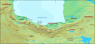
English: Northern Iran and its surroundings during the Iranian intermezzo. The borders are supposed to represent the traditional geographical boundaries of each region. |
| Date | |
| Source |
|
| Author | HistoryofIran |
Licensing edit
I, the copyright holder of this work, hereby publish it under the following licenses:

|
Permission is granted to copy, distribute and/or modify this document under the terms of the GNU Free Documentation License, Version 1.2 or any later version published by the Free Software Foundation; with no Invariant Sections, no Front-Cover Texts, and no Back-Cover Texts. A copy of the license is included in the section entitled GNU Free Documentation License. |
This file is licensed under the Creative Commons Attribution-Share Alike 4.0 International license.
- You are free:
- to share – to copy, distribute and transmit the work
- to remix – to adapt the work
- Under the following conditions:
- attribution – You must give appropriate credit, provide a link to the license, and indicate if changes were made. You may do so in any reasonable manner, but not in any way that suggests the licensor endorses you or your use.
- share alike – If you remix, transform, or build upon the material, you must distribute your contributions under the same or compatible license as the original.
You may select the license of your choice.
File history
Click on a date/time to view the file as it appeared at that time.
| Date/Time | Thumbnail | Dimensions | User | Comment | |
|---|---|---|---|---|---|
| current | 23:54, 19 October 2020 | | 3,562 × 1,652 (1.79 MB) | HistoryofIran (talk | contribs) | improvement |
| 23:44, 19 October 2020 |  | 3,562 × 1,652 (1.76 MB) | HistoryofIran (talk | contribs) | object to paths | |
| 23:42, 19 October 2020 |  | 3,562 × 1,652 (1.46 MB) | HistoryofIran (talk | contribs) | {{subst:Upload marker added by en.wp UW}} {{Information |Description = {{en|Northern Iran and its surroundings during the Iranian intermezzo.}} |Source = {{own}} |Date = 20 October 2020 |Author = HistoryofIran }} |
You cannot overwrite this file.
File usage on Commons
The following page uses this file:
File usage on other wikis
The following other wikis use this file:
- Usage on bn.wikipedia.org
- Usage on ca.wikipedia.org
- Usage on cbk-zam.wikipedia.org
- Usage on ckb.wikipedia.org
- Usage on de.wikipedia.org
- Usage on en.wikipedia.org
- Yazid ibn al-Muhallab
- Tabaristan
- Farrukhan the Great
- User:HistoryofIran/Articles
- User talk:Donald Trung
- User talk:Sadenar40000
- Ruyan (district)
- User:Falcaorib
- User talk:NgocAnMaster
- User talk:ZI Jony/Translation of the week
- User talk:Dapanay
- User talk:Lacessori
- User talk:Haoreima
- User talk:Xeverything11
- User talk:SilkPyjamas
- User:Al Ameer son/Yazid ibn al-Muhallab
- User talk:Tahmid/Archives/2024/05
- Usage on en.wikibooks.org
- Usage on en.wiktionary.org
- Usage on es.wikipedia.org
- Usuario discusión:Macacc
- Usuario discusión:Broyito
- Usuario discusión:Fergthh
- Usuario discusión:Agusbou2015
- Usuario discusión:Ignacio2403
- Usuario discusión:Uvulum
- Usuario discusión:Mroruga
- Usuario discusión:Términus
- Usuario discusión:Cysquatch
- Usuaria discusión:Lana del Reno
- Usuario discusión:SDAR04
- Ruyan (distrito)
- Usage on fa.wikipedia.org
- Usage on gl.wikipedia.org
- Usage on ht.wikipedia.org
- Usage on id.wikipedia.org
- Usage on incubator.wikimedia.org
View more global usage of this file.