File:Noszlopy-Jubál-Sárközy plaque (Budapest-09 Telepy u 2c).jpg
Size of this preview: 439 × 599 pixels. Other resolutions: 176 × 240 pixels | 352 × 480 pixels | 563 × 768 pixels | 751 × 1,024 pixels | 1,933 × 2,636 pixels.
Original file (1,933 × 2,636 pixels, file size: 1.61 MB, MIME type: image/jpeg)
Captions
Captions
Add a one-line explanation of what this file represents
Summary edit
.jpg&action=edit§ion=1)
| Description |
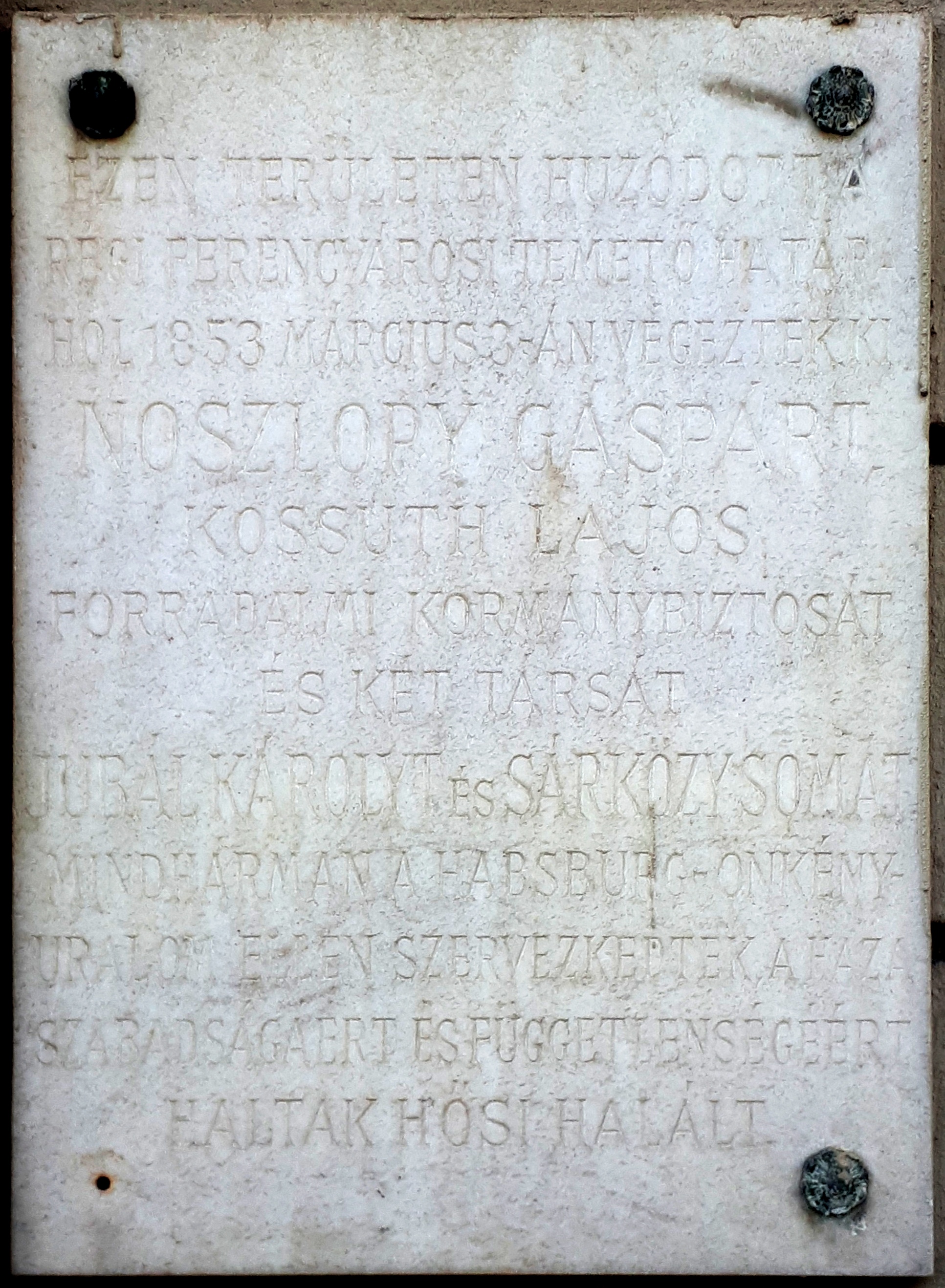
English: Commemorative plaque to Messrs Gáspár Noszlopy (1820–1853) Hungarian government commissioner in 1849, Károly Jubal (1817–1853) teacher and Soma Sárközy (1821–1853) lawyer. It is affixed to the wall of a building where the old Ferencváros cemetery was on the outskirts of the city of Pest, the place where the three Hungarian martyrs of the conspiracies following the War of Independence of 1848-1849 were hanged on March 3, 1853. (Budapest, District IX, Telepy Street Nr 2/C)
Français : Plaque commémorative aux MM. Gáspár Noszlopy (1820–1853) commissaire gouvernemental en 1849, Károly Jubál (1817–1853) enseignant et Soma Sárközy (1821–1853) juriste. Elle est apposée au mur d’un immeuble où se trouvait autrefois le vieux cimetière de Ferencváros à la périphérie de la ville de Pest, le lieu où les trois martyrs hongrois des conspirations suivant la guerre d'indépendance de 1848-1849 ont été pendus le 3 mars 1853. (2ter rue Telepy, Budapest 9e arr.)
Magyar: Noszlopy Gáspár (1820–1853) kormánybiztos, Jubál Károly (1817–1853) tanár és Sárközy Soma (1821–1853) ügyvéd, az 1848–49-es szabadságharcot követő függetlenségi szervezkedések három vértanújának emléktáblája az egykori Pest határában fekvő régi ferencvárosi temető mentén emelt épületen, ahol 1853. március 3-án felakasztották őket. (Budapest IX. ker., Telepy utca 2/C.) |
| Date | Taken on 2 July 2018, 16:06:04 |
| Source | Own work |
| Author | Fekist |
| Camera location | | View this and other nearby images on: OpenStreetMap |
|---|
.jpg¶ms=047.477162_N_0019.080958_E_globe:Earth_type:camera__&language=en)
Licensing edit
.jpg&action=edit§ion=2)
I, the copyright holder of this work, hereby publish it under the following license:
This file is licensed under the Creative Commons Attribution-Share Alike 4.0 International license.
- You are free:
- to share – to copy, distribute and transmit the work
- to remix – to adapt the work
- Under the following conditions:
- attribution – You must give appropriate credit, provide a link to the license, and indicate if changes were made. You may do so in any reasonable manner, but not in any way that suggests the licensor endorses you or your use.
- share alike – If you remix, transform, or build upon the material, you must distribute your contributions under the same or compatible license as the original.
File history
Click on a date/time to view the file as it appeared at that time.
| Date/Time | Thumbnail | Dimensions | User | Comment | |
|---|---|---|---|---|---|
| current | 15:00, 3 July 2018 | | 1,933 × 2,636 (1.61 MB) | Fekist (talk | contribs) | User created page with UploadWizard |
You cannot overwrite this file.
File usage on Commons
The following 2 pages use this file:
File usage on other wikis
The following other wikis use this file:
- Usage on hu.wikipedia.org
.jpg&oldid=771774047)