File:Nouveau plan complet de Paris avec ses fortifications by J. N. Henriot, 1853 - Stanford Libraries.jpg

Size of this preview: 800 × 550 pixels. Other resolutions: 320 × 220 pixels | 640 × 440 pixels | 1,024 × 704 pixels | 1,280 × 880 pixels | 2,560 × 1,760 pixels | 13,584 × 9,338 pixels.
Original file (13,584 × 9,338 pixels, file size: 23.78 MB, MIME type: image/jpeg)
Captions
Captions
Add a one-line explanation of what this file represents
Summary edit
| Warning | The original file is very high-resolution. It might not load properly or could cause your browser to freeze when opened at full size. |
|---|
| Title |
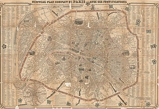
Nouveau plan complet de Paris avec ses fortifications : divisé en 12 arrondissements & 48 sections avec les principaux monuments en elévation, donnant la distance légale en mètres des forts détachés aux murs d'enceinte & aux murs d'octroi : indiquant la population & les fêtes patronales des environs de Paris |
| Description |
English: Relief shown pictorially. Inset: Environs de Paris indiquant tous les forts. Selected buildings shown pictorially. Includes index of street names. |
| Date | |
| Source | Stanford Libraries |
| Creator |
J. N. Henriot |
| Georeferencing | If inappropriate please set warp_status = skip to hide. |
| Bibliographic data | |
| Publisher |
À Paris : Chez A. Bes et F. Dubreuil, editeurs-imprimeurs ... , 1853. |
| Archival data | |
| Collection | Stanford Libraries |
| Medium | 1 map |
Licensing edit
|
This work is in the public domain in its country of origin and other countries and areas where the copyright term is the author's life plus 100 years or fewer. | |
| This file has been identified as being free of known restrictions under copyright law, including all related and neighboring rights. | |
File history
Click on a date/time to view the file as it appeared at that time.
| Date/Time | Thumbnail | Dimensions | User | Comment | |
|---|---|---|---|---|---|
| current | 05:31, 10 July 2020 | | 13,584 × 9,338 (23.78 MB) | Paris 16 (talk | contribs) | Uploaded own work with UploadWizard |
You cannot overwrite this file.
File usage on Commons
The following page uses this file: