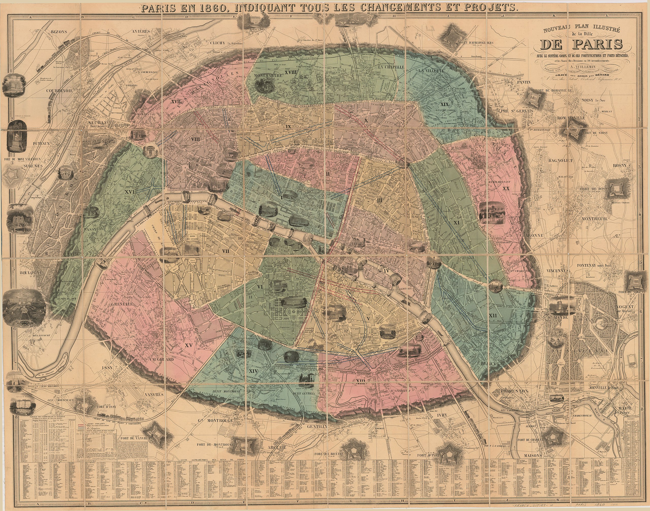
File:Nouveau plan illustré de la ville de Paris by Alexandre Vuillemin, 1860 - Stanford Libraries.jpg

Size of this preview: 763 × 600 pixels. Other resolutions: 305 × 240 pixels | 611 × 480 pixels | 977 × 768 pixels | 1,280 × 1,006 pixels | 2,560 × 2,013 pixels | 17,303 × 13,603 pixels.
Original file (17,303 × 13,603 pixels, file size: 42.92 MB, MIME type: image/jpeg)
Captions
Captions
Add a one-line explanation of what this file represents
Summary
edit
| Warning | The original file is very high-resolution. It might not load properly or could cause your browser to freeze when opened at full size. |
|---|
| Title |
Nouveau plan illustré de la ville de Paris avec le système complet de ses fortifications et forts détachés et les nouvelles divisions en 20 arrondissements |
| Description |
English: In upper margin: Paris en 1860, indiquant tous les changements et projets. Includes indexes, illustrations of buildings, bridges and forts and distance table. Originally issued folded in covers, 22 x 14 cm. |
| Date | |
| Source | Stanford Libraries |
| Creator |
Alexandre Vuillemin |
| Georeferencing | If inappropriate please set warp_status = skip to hide. |
| Bibliographic data | |
| Publisher |
À Paris : chez Fatout, Boulevard Poissonnière no. 17, [1860] |
| Archival data | |
| Collection | Stanford Libraries |
| Dimensions | 22 x 14 cm |
| Medium | 1 map |
Licensing
edit
|
This work is in the public domain in its country of origin and other countries and areas where the copyright term is the author's life plus 100 years or fewer. | |
| This file has been identified as being free of known restrictions under copyright law, including all related and neighboring rights. | |
File history
Click on a date/time to view the file as it appeared at that time.
| Date/Time | Thumbnail | Dimensions | User | Comment | |
|---|---|---|---|---|---|
| current | 05:31, 10 July 2020 | | 17,303 × 13,603 (42.92 MB) | Paris 16 (talk | contribs) | Uploaded own work with UploadWizard |
You cannot overwrite this file.
File usage on Commons
The following page uses this file: