File:Nouvelle carte d'Europe.png

Size of this preview: 800 × 576 pixels. Other resolutions: 320 × 230 pixels | 640 × 461 pixels | 1,024 × 737 pixels | 1,280 × 921 pixels | 2,560 × 1,843 pixels | 9,146 × 6,583 pixels.
Original file (9,146 × 6,583 pixels, file size: 134.66 MB, MIME type: image/png)
Captions
Captions
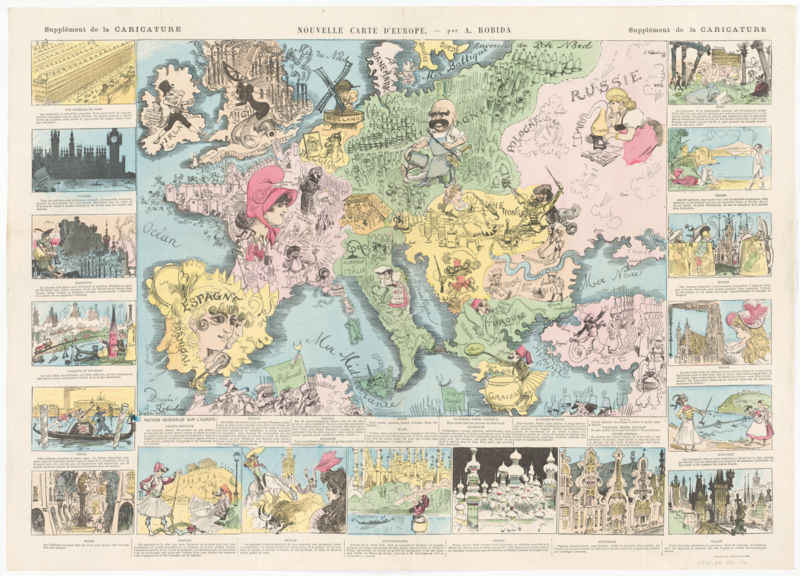
Nouvelle carte d'Europe
Summary edit
| Description |
English: Nouvelle carte d'Europe |
||||||||||||||||||||
| Date | between 1880 and 1892 | ||||||||||||||||||||
| Source | https://id.lib.harvard.edu/curiosity/scanned-maps/44-990142735370203941 | ||||||||||||||||||||
| Author |
Creation Date: [between 1880 and 1892] Place Of Origin: France [Paris] : Sceaux : Publisher: [Librairie illustrée], |
||||||||||||||||||||
.png)
Licensing edit
|
This work is in the public domain in its country of origin and other countries and areas where the copyright term is the author's life plus 70 years or fewer. This work is in the public domain in the United States because it was published (or registered with the U.S. Copyright Office) before January 1, 1929. | |
| This file has been identified as being free of known restrictions under copyright law, including all related and neighboring rights. | |
File history
Click on a date/time to view the file as it appeared at that time.
| Date/Time | Thumbnail | Dimensions | User | Comment | |
|---|---|---|---|---|---|
| current | 08:44, 1 July 2020 | | 9,146 × 6,583 (134.66 MB) | Balkanique (talk | contribs) | Uploaded a work by Creator/Contributor: Robida, Albert, 1848-1926, creator Creation Date: [between 1880 and 1892] Place Of Origin: France [Paris] : Sceaux : Publisher: [Librairie illustrée], from https://id.lib.harvard.edu/curiosity/scanned-maps/44-990142735370203941 with UploadWizard |
You cannot overwrite this file.
File usage on Commons
The following page uses this file: