File:Nova Scotia DGJ 4956 - St. Peters Canal National Historic Site of Canada (6465296537).jpg

Original file (4,385 × 2,996 pixels, file size: 9.43 MB, MIME type: image/jpeg)
Captions
Captions
Summary edit
.jpg&action=edit§ion=1)
| Description |
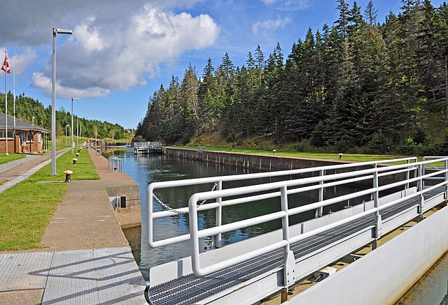
PLEASE, no multi invitations, glitters or self promotion in your comments. My photos are FREE for anyone to use, just give me credit and it would be nice if you let me know, thanks - NONE OF MY PICTURES ARE HDR. St. Peters Canal is an 800 metre (2,625ft) canal linking the Atlantic Ocean with Bras d'Or Lake. Work started on the canal in 1854 and was completed in 1869. The canal also boasts the only functioning lock system in Nova Scotia. There is tidal activity at both ends of the canal, and there can be a difference of up to 1.4 m (4.5 ft.) between the water level of the lake and ocean. For this reason, both entrances have double-lock gates. The lock is 91.44 m (301 ft.) long by 14.45 m (47 ft.) wide and can handle vessels with a 4.88 m (16 ft.) draught. In the 1630s, enterprising merchants from La Rochelle in France built a small fortified settlement, called Saint Pierre, on a narrow isthmus of land separating the Atlantic Ocean from Bras d'Or Lake. The area had long been travelled by the Mi'kmaq people who portaged their canoes across the isthmus. To protect the new settlement and transportation across the isthmus, the French built a fort on the shore. Both the fort and the settlement were destroyed by the British in 1758 after their capture of Louisbourg. With a steadily increasing volume of shipping, plans were soon made to replace the old portage road with a navigation channel. The first feasibility study was commissioned in 1825, and work on the canal began in 1854. A passage about 800 meters (2625ft.) long was cut through the narrowest point of land. After 15 years of digging, blasting and drilling, an opening averaging 30 meters (100 ft.) wide had been cut through a solid granite hill 20 meters (66 ft.) high. This passage was shored up with timbers and planking. Locks were then installed and the canal finally became a reality in 1869. Additions and renovations, widening the channel and lengthening the locks, continued until 1917. In 1985, Parks Canada completed a major project to restore both the Bras d'Or Lake and the Atlantic Ocean entrances to the canal. All kinds of pleasure craft now use the canal during the summer: canoes, schooners and power cruisers. Only occasionally does a commercial vessel pass through these locks that once were so vital to communication and the economy of Cape Breton Island. |
| Date | |
| Source | DGJ_4956 - St. Peters Canal National Historic Site of Canada |
| Author | Dennis Jarvis from Halifax, Canada |
| Permission (Reusing this file) |
Quote from photographer on numerous files
Quote from photographer on numerous files
|
| Camera location | | View this and other nearby images on: OpenStreetMap |
|---|
.jpg¶ms=045.652118_N_-060.869922_E_globe:Earth_type:camera_source:Flickr_&language=en)
Licensing edit
.jpg&action=edit§ion=2)
- You are free:
- to share – to copy, distribute and transmit the work
- to remix – to adapt the work
- Under the following conditions:
- attribution – You must give appropriate credit, provide a link to the license, and indicate if changes were made. You may do so in any reasonable manner, but not in any way that suggests the licensor endorses you or your use.
- share alike – If you remix, transform, or build upon the material, you must distribute your contributions under the same or compatible license as the original.
| This image was originally posted to Flickr by archer10 (Dennis) 116M Views at https://flickr.com/photos/22490717@N02/6465296537 (archive). It was reviewed on 1 March 2018 by FlickreviewR 2 and was confirmed to be licensed under the terms of the cc-by-sa-2.0. |
File history
Click on a date/time to view the file as it appeared at that time.
| Date/Time | Thumbnail | Dimensions | User | Comment | |
|---|---|---|---|---|---|
| current | 01:26, 1 March 2018 | | 4,385 × 2,996 (9.43 MB) | Artix Kreiger 2 (talk | contribs) | Transferred from Flickr via Flickr2Commons |
You cannot overwrite this file.
File usage on Commons
There are no pages that use this file.
.jpg&oldid=802026570)