File:Novate Milanese - mappa reticolo idrico.svg

Size of this PNG preview of this SVG file: 564 × 599 pixels. Other resolutions: 226 × 240 pixels | 452 × 480 pixels | 723 × 768 pixels | 964 × 1,024 pixels | 1,928 × 2,048 pixels | 868 × 922 pixels.
Original file (SVG file, nominally 868 × 922 pixels, file size: 1.64 MB)
Captions
Captions
Add a one-line explanation of what this file represents
Summary
edit| Description |
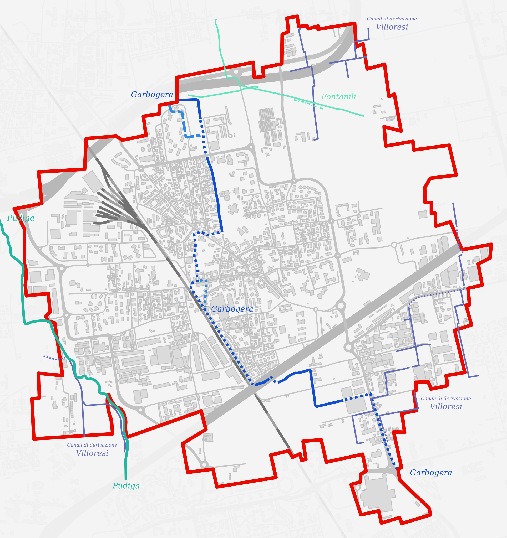
Italiano: Mappa di Novate Milanese, con evidenza del reticolo idrico principale e minore. Dati: Pubblico dominio - Comune di Novate Milanese - dicembre 2013.
Torrente Garbogera
Torrente Garbogera tombinato
Torrente Garbogera (tratto abbandonato)
Torrente Garbogera (tratto tombinato abbandonato)
Torrente Pudiga
Canali di derivazione Villoresi
Canali di derivazione Villoresi tombinati
Fontanili
Fontanile abbandonato |
||||
| Date | |||||
| Source | Own work based on: Novate Milanese - mappa unità di paesaggio.svg. Location of the streams from https://mycity.s3.sbg.io.cloud.ovh.net/3317936/tav_1_carta_inquadramento_bz2_-_dicembre_2013.pdf (released in the public domain by the municipality of Novate Milanese (Italy) as stated here. Base map (borders, roads, railway, buildings) from OpenStreetMap. | ||||
| Author |
|
||||
| Permission (Reusing this file) |
|
||||
| Other versions |
|

File history
Click on a date/time to view the file as it appeared at that time.
| Date/Time | Thumbnail | Dimensions | User | Comment | |
|---|---|---|---|---|---|
| current | 15:29, 29 May 2024 | | 868 × 922 (1.64 MB) | Arrow303 (talk | contribs) | ferrovia in grigio |
| 07:30, 30 April 2024 |  | 814 × 864 (1.64 MB) | Arrow303 (talk | contribs) | typo | |
| 20:07, 29 April 2024 |  | 814 × 864 (1.64 MB) | Arrow303 (talk | contribs) | {{Information |Description={{it|Mappa di Novate Milanese, con evidenza del reticolo idrico principale e minore. Dati: Pubblico dominio - Comune di Novate Milanese - dicembre 2013. {{Legend |#114ecd|Torrente Garbogera}} {{Legend |#114ecd|Torrente Garbogera tombinato| striped=3}} {{Legend |#2f89df|Torrente Garbogera (tratto abbandonato)}} {{Legend |#2f89df|Torrente Garbogera (tratto tombinato abbandonato)|striped=3}} {{Legend |#21b6a0|Torrente Pudiga}} {{Legend |#636cb7|Canali di derivazi... |
You cannot overwrite this file.
File usage on Commons
There are no pages that use this file.
File usage on other wikis
The following other wikis use this file:
- Usage on it.wikipedia.org