File:Nuernberg-Hainberg.svg

Size of this PNG preview of this SVG file: 506 × 600 pixels. Other resolutions: 202 × 240 pixels | 405 × 480 pixels | 648 × 768 pixels | 864 × 1,024 pixels | 1,728 × 2,048 pixels | 518 × 614 pixels.
Original file (SVG file, nominally 518 × 614 pixels, file size: 566 KB)
Captions
Captions
Add a one-line explanation of what this file represents
| Description |
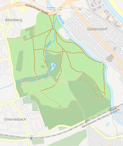
English: Map of the Hainberg in Nürnberg, Germany |
||||||||||||
| Date | |||||||||||||
| Source | Own work, using OpenStreetMap data | ||||||||||||
| Author | Carport | ||||||||||||
| Permission (Reusing this file) |
|
||||||||||||
| Other versions | File:Hainberg-Lageplan.png |
File history
Click on a date/time to view the file as it appeared at that time.
| Date/Time | Thumbnail | Dimensions | User | Comment | |
|---|---|---|---|---|---|
| current | 15:31, 16 July 2010 | | 518 × 614 (566 KB) | Carport (talk | contribs) | text to path |
| 15:29, 16 July 2010 |  | 518 × 614 (520 KB) | Carport (talk | contribs) | {{Information |Description={{en|Map of the ''Hainberg'' in Nürnberg, Germany}} |Source={{own}}, using OpenStreetMap data |Date=2010-07-16 |Author={{u|Carport}} |Permission={{OpenStreetMap}} |other_versions=File:Hainberg-Lageplan.png }} [[Cat |
You cannot overwrite this file.
File usage on Commons
The following page uses this file:
File usage on other wikis
The following other wikis use this file:
- Usage on de.wikipedia.org
- Usage on www.wikidata.org