File:Nueva Cartago y Costa Rica (1540).PNG
Nueva_Cartago_y_Costa_Rica_(1540).PNG (393 × 456 pixels, file size: 14 KB, MIME type: image/png)
File information
Structured data
Captions
Captions
Add a one-line explanation of what this file represents
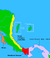
| DescriptionNueva Cartago y Costa Rica (1540).PNG | Mapa de Centroamérica en 1540, tras la creación del Ducado de Veragua. A consecuencia de la creación del Ducado en favor de los nietos de Cristóbal Colón, los territorios restantes de la Veragua real, separados de Castilla del Oro por el Ducado, formaron la Provincia de Nueva Cartago y Costa Rica, que se extendía desde la frontera del Ducado, en la isla del Escudo de Veragua (actual Panamá) hasta el río Aguán (actual Honduras). Diego Gutiérrez y Toledo intentaría conquistar infructuosamente el territorio de Nueva Cartago y Costa Rica entre 1540 y 1544, cuando murió en un ataque indígena. El territorio de Nicoya formaba parte de la Provincia de Nicaragua desde 1520 y hasta 1554, cuando se creó el Corregimiento de Nicoya. |
| Date | (UTC) |
| Source | |
| Author |
|
| This is a retouched picture, which means that it has been digitally altered from its original version. Modifications: Se recorta el mapa para enfatizar el área de interés (Centroamérica). Se delimitan por colores los territorios de Nueva Cartago y Costa Rica, la Provincia de Nicaragua, Nicoya, el Ducado de Veragua y Castilla del Oro, según Botey Sobrado, Ana María (2002) (en español). Costa Rica: desde las sociedades autóctonas hasta 1914. Editorial de la Universidad de Costa Rica. pp. 82-83 ISBN 9977-67-694-1.. The original can be viewed here: Cambios territoriales de Colombia.png:
|
I, the copyright holder of this work, hereby publish it under the following licenses:
This file is licensed under the Creative Commons Attribution-Share Alike 3.0 Unported, 2.5 Generic, 2.0 Generic and 1.0 Generic license.
- You are free:
- to share – to copy, distribute and transmit the work
- to remix – to adapt the work
- Under the following conditions:
- attribution – You must give appropriate credit, provide a link to the license, and indicate if changes were made. You may do so in any reasonable manner, but not in any way that suggests the licensor endorses you or your use.
- share alike – If you remix, transform, or build upon the material, you must distribute your contributions under the same or compatible license as the original.

|
Permission is granted to copy, distribute and/or modify this document under the terms of the GNU Free Documentation License, Version 1.2 or any later version published by the Free Software Foundation; with no Invariant Sections, no Front-Cover Texts, and no Back-Cover Texts. A copy of the license is included in the section entitled GNU Free Documentation License.http://www.gnu.org/copyleft/fdl.htmlGFDLGNU Free Documentation Licensetruetrue |
You may select the license of your choice.
Original upload log edit
This image is a derivative work of the following images:
- File:Cambios territoriales de Colombia.png licensed with Cc-by-sa-3.0,2.5,2.0,1.0, GFDL
Uploaded with derivativeFX
File history
Click on a date/time to view the file as it appeared at that time.
| Date/Time | Thumbnail | Dimensions | User | Comment | |
|---|---|---|---|---|---|
| current | 21:15, 22 September 2011 |  | 393 × 456 (14 KB) | Rodtico21 (talk | contribs) | {{Information |Description=Mapa de Centroamérica en 1540, tras la creación del Ducado de Veragua. A consecuencia de la creación del Ducado en favor de los nietos de Cristóbal Colón, los territorios restantes de la Veragua real, separados de [ |
You cannot overwrite this file.
File usage on Commons
There are no pages that use this file.
File usage on other wikis
The following other wikis use this file:
- Usage on br.wikipedia.org
- Usage on es.wikipedia.org
- Usage on fr.wikipedia.org
- Usage on lt.wikipedia.org