File:Nut Island MA 1946.png

Size of this preview: 800 × 600 pixels. Other resolutions: 320 × 240 pixels | 640 × 480 pixels | 1,024 × 768 pixels | 1,304 × 978 pixels.
Original file (1,304 × 978 pixels, file size: 1.16 MB, MIME type: image/png)
Captions
Captions
Add a one-line explanation of what this file represents
Summary
edit
| Description |
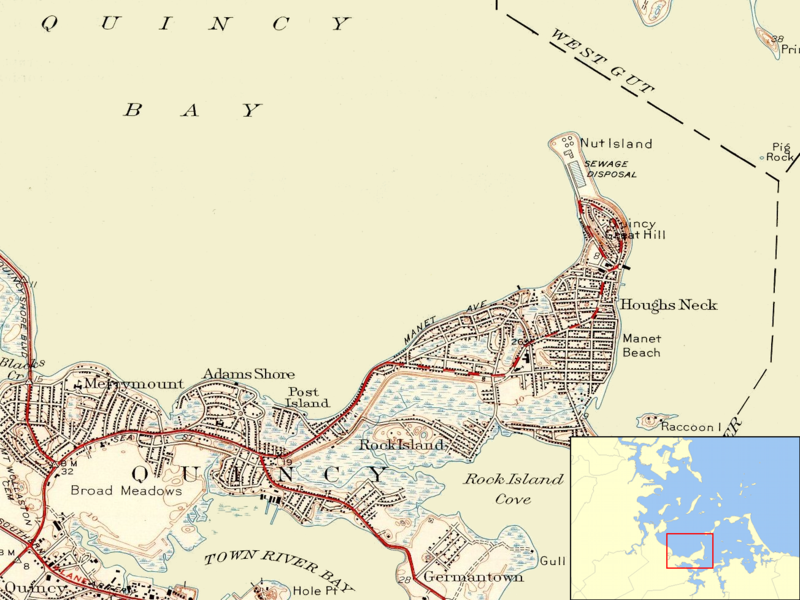
English: Map showing the position of Nut Island on the eastern shore of Quincy Bay with inset showing the location of the mapped area in Boston Harbor. |
| Date | 1946, revised 1949 |
| Source | U.S. Geological Survey, obtained from University of New Hampshire collection http://docs.unh.edu/MA/hull50sw.jpg |
| Author | USGS |
| This is a retouched picture, which means that it has been digitally altered from its original version. Modifications: Cropped from full map, background noise removed using Gimp.
|
Licensing
edit
This image is in the public domain in the United States because it only contains materials that originally came from the United States Geological Survey, an agency of the United States Department of the Interior. For more information, see the official USGS copyright policy.
|
File history
Click on a date/time to view the file as it appeared at that time.
| Date/Time | Thumbnail | Dimensions | User | Comment | |
|---|---|---|---|---|---|
| current | 06:53, 11 June 2009 | | 1,304 × 978 (1.16 MB) | Sswonk (talk | contribs) | {{Information |Description={{en|1=Map showing the position of Nut Island on the eastern shore of Quincy Bay with inset showing the location of the mapped area in Boston Harbor.}} |Source=U.S. Geological Survey, obtained from University of New Hampshire co |
You cannot overwrite this file.
File usage on Commons
There are no pages that use this file.
File usage on other wikis
The following other wikis use this file:
- Usage on de.wikipedia.org
- Usage on en.wikipedia.org
- Usage on www.wikidata.org