File:Nyafolkland.png
No higher resolution available.
Nyafolkland.png (530 × 599 pixels, file size: 221 KB, MIME type: image/png)
Captions
Captions
Add a one-line explanation of what this file represents

|
This locator map image could be re-created using vector graphics as an SVG file. This has several advantages; see Commons:Media for cleanup for more information. If an SVG form of this image is available, please upload it and afterwards replace this template with
{{vector version available|new image name}}.
It is recommended to name the SVG file “Nyafolkland.svg”—then the template Vector version available (or Vva) does not need the new image name parameter. |
Summary
edit
| Description |
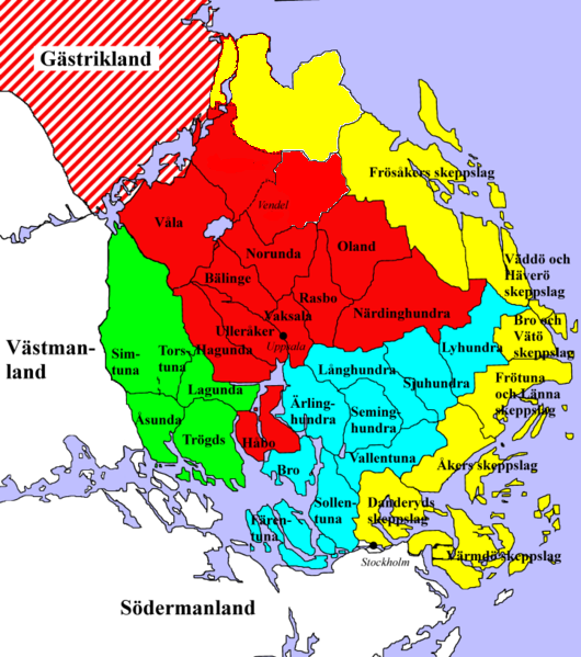
English: Map of Uppland, a historical province Sweden, divided into "folklands" and the smaller "härads", circa 1250. Legend:
Svenska: Karta över Uppland, uppdelat i folkland och härader i mitten av 1200-talet. Teckenförklaring:
|
| Source | Own work |
| Author | FBQ |
Licensing
edit
| I, the copyright holder of this work, release this work into the public domain. This applies worldwide. In some countries this may not be legally possible; if so: I grant anyone the right to use this work for any purpose, without any conditions, unless such conditions are required by law. |
File history
Click on a date/time to view the file as it appeared at that time.
| Date/Time | Thumbnail | Dimensions | User | Comment | |
|---|---|---|---|---|---|
| current | 21:09, 14 July 2009 | | 530 × 599 (221 KB) | FBQ (talk | contribs) | {{Information |Description= |Source=self-made |Date= |Author= FBQ |Permission= |other_versions= }} |
You cannot overwrite this file.
File usage on Commons
There are no pages that use this file.
File usage on other wikis
The following other wikis use this file:
- Usage on en.wikipedia.org
- Usage on fi.wikipedia.org
- Usage on it.wikipedia.org
- Usage on pl.wikipedia.org
- Usage on pt.wikipedia.org
- Usage on sv.wikipedia.org