File:OECD memberstates.svg

Size of this PNG preview of this SVG file: 800 × 353 pixels. Other resolutions: 320 × 141 pixels | 640 × 283 pixels | 1,024 × 452 pixels | 1,280 × 565 pixels | 2,560 × 1,130 pixels | 940 × 415 pixels.
Original file (SVG file, nominally 940 × 415 pixels, file size: 1.51 MB)
Captions
Captions
Add a one-line explanation of what this file represents
| Description |
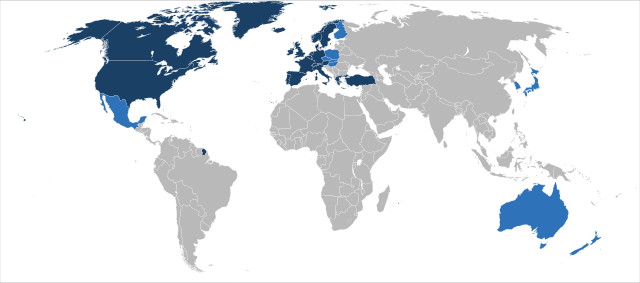
Original members
New members
Map of member states of the OECD. Deutsch: Mitgliedstaaten der OECD
English: OECD member states
Español: Mapa de los Estados miembros de la OCDE
Suomi: Kartta jäsenmaista
Français : Pays membres de l'OCDE
Italiano: Stati membri dell'OCSE
Polski: Państwa członkowskie OECD
Português: Os membros da OCDE estão indicados a azul
Türkçe: OECD'ye üye ülkeler |
| Date | (UTC) |
| Source | |
| Author |
|
This W3C-unspecified vector image was created with Inkscape .
This file is licensed under the Creative Commons Attribution 3.0 Unported license.
- You are free:
- to share – to copy, distribute and transmit the work
- to remix – to adapt the work
- Under the following conditions:
- attribution – You must give appropriate credit, provide a link to the license, and indicate if changes were made. You may do so in any reasonable manner, but not in any way that suggests the licensor endorses you or your use.
Original upload log
edit
This image is a derivative work of the following images:
- Image:BlankMap-World6,_compact.svg licensed with PD-user
- 2008-06-13T14:51:25Z Lokal Profil 940x415 (1518276 Bytes) Syncing with [[:Image:BlankMap-World6.svg]] version (01:30, March 29, 2008). Sadly enough the validator does not seem to like rdf element of the metadata although it should work acording to http://www.w3schools.com/rdf/rdf_ma
- 2008-02-08T20:55:35Z CarolSpears 940x415 (1528750 Bytes) validated, maybe
- 2007-12-14T19:51:17Z Lokal Profil 940x415 (1529675 Bytes) Readded an ocean object but this one is square instead of the original elliptic one
- 2007-12-14T19:19:56Z Lokal Profil 940x415 (1529845 Bytes) {{Information |Description=Detailed SVG map with grouping enabled to connect all non-contiguous parts of a country's territory for easy colouring. Smaller countries can also be represented by larger circles to show their data
Uploaded with derivativeFX
File history
Click on a date/time to view the file as it appeared at that time.
| Date/Time | Thumbnail | Dimensions | User | Comment | |
|---|---|---|---|---|---|
| current | 14:21, 15 October 2008 | | 940 × 415 (1.51 MB) | ~Pyb (talk | contribs) | {{Information |Description=Map of member states of the OECD. {{de|Mitgliedstaaten der OECD}} {{en|OECD member states}} {{es|Mapa de los Estados miembros de la OCDE}} {{fi|Kartta jäsenmaista}} {{fr|Pays membres de l'OCDE}} {{it|Stati membri dell'OCSE}} {{ |
You cannot overwrite this file.
File usage on Commons
There are no pages that use this file.