File:OEF-map-4.jpg

Size of this preview: 800 × 523 pixels. Other resolutions: 320 × 209 pixels | 640 × 419 pixels | 1,000 × 654 pixels.
Original file (1,000 × 654 pixels, file size: 100 KB, MIME type: image/jpeg)
Captions
Captions
Add a one-line explanation of what this file represents
This file is a work of a U.S. Army soldier or employee, taken or made as part of that person's official duties. As a work of the U.S. federal government, it is in the public domain in the United States.
|
 |
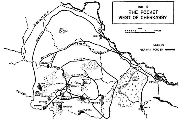
"The Pocket West of Cherkassy", map 4 from Operations of Encircled Forces:German Experiences in Russia, showing the formation of the Korsun-Cherkassy Pocket and the route of the breakout, January-February 1943.
File history
Click on a date/time to view the file as it appeared at that time.
| Date/Time | Thumbnail | Dimensions | User | Comment | |
|---|---|---|---|---|---|
| current | 12:48, 26 April 2005 | | 1,000 × 654 (100 KB) | Bobby D. Bryant~commonswiki (talk | contribs) | Map 4 from ''Operations of Encircled Forces:German Experiences in Russia'' |
You cannot overwrite this file.
File usage on Commons
The following page uses this file:
File usage on other wikis
The following other wikis use this file:
- Usage on de.wikipedia.org
- Usage on es.wikipedia.org
- Usage on he.wikipedia.org
- Usage on vi.wikipedia.org