File:OHZ topografie.png
Size of this preview: 706 × 600 pixels. Other resolutions: 283 × 240 pixels | 565 × 480 pixels | 904 × 768 pixels | 1,255 × 1,066 pixels.
Original file (1,255 × 1,066 pixels, file size: 298 KB, MIME type: image/png)
Captions
Captions
Add a one-line explanation of what this file represents
Summary
edit
| Description |
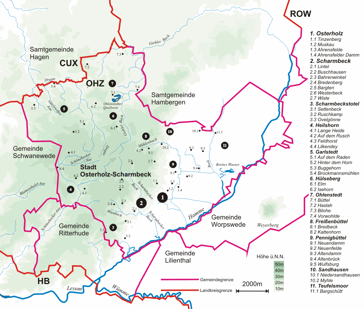
Deutsch: Topografische Karte des Stadtgebiets von Osterholz-Scharmbeck. Neben der Hamme im östlichen Teil fällt insbesondere der Rücken der Osterholzer-Geest (Lange Heide) mit den zahlreichen Geestrandbächen auf. |
| Date | 6.7.07 |
| Source | selbstgemalt |
| Author | CWitte |

|
This city map image could be re-created using vector graphics as an SVG file. This has several advantages; see Commons:Media for cleanup for more information. If an SVG form of this image is available, please upload it and afterwards replace this template with
{{vector version available|new image name}}.
It is recommended to name the SVG file “OHZ topografie.svg”—then the template Vector version available (or Vva) does not need the new image name parameter. |
Licensing
edit
CWitte at the German-language Wikipedia, the copyright holder of this work, hereby publishes it under the following license:

|
Permission is granted to copy, distribute and/or modify this document under the terms of the GNU Free Documentation License, Version 1.2 or any later version published by the Free Software Foundation; with no Invariant Sections, no Front-Cover Texts, and no Back-Cover Texts. A copy of the license is included in the section entitled GNU Free Documentation License. |
| This file is licensed under the Creative Commons Attribution-Share Alike 3.0 Unported license. | ||
| Attribution: CWitte | ||
| ||
| This licensing tag was added to this file as part of the GFDL licensing update. |
Original upload log
edit
Transferred from de.wikipedia to Commons by Ireas using CommonsHelper.
The original description page was here. All following user names refer to de.wikipedia.
- 2007-07-06 12:56 CWitte 1255×1066× (304962 bytes) {{Information |Beschreibung = |Quelle = |Urheber = |Datum = |Genehmigung = |Andere Versionen = |Anmerkungen = }}
- 2007-07-06 12:31 CWitte 1269×995× (291976 bytes) {{Information |Beschreibung = |Quelle = |Urheber = |Datum = |Genehmigung = |Andere Versionen = |Anmerkungen = }}
- 2007-07-06 12:19 CWitte 824×783× (168121 bytes) {{Information |Beschreibung = Topografische Karte des Stadtgebiets von Osterholz-Scharmbeck |Quelle = selbstgemalt |Urheber = ~~~ |Datum = 6.7.07 |Genehmigung = |Andere Versionen = |Anmerkungen = }}
File history
Click on a date/time to view the file as it appeared at that time.
| Date/Time | Thumbnail | Dimensions | User | Comment | |
|---|---|---|---|---|---|
| current | 16:05, 19 October 2010 | | 1,255 × 1,066 (298 KB) | File Upload Bot (Magnus Manske) (talk | contribs) | {{BotMoveToCommons|de.wikipedia|year={{subst:CURRENTYEAR}}|month={{subst:CURRENTMONTHNAME}}|day={{subst:CURRENTDAY}}}} {{Information |Description={{de|Topografische Karte des Stadtgebiets von Osterholz-Scharmbeck. Neben der de:Hamme im östlichen T |
You cannot overwrite this file.
File usage on Commons
The following 9 pages use this file:
File usage on other wikis
The following other wikis use this file:
- Usage on azb.wikipedia.org
- Usage on de.wikipedia.org
- Usage on ja.wikipedia.org
- Usage on nl.wikipedia.org
- Usage on www.wikidata.org