File:OSM Karte Ehemalige Bahnlinie Feucht-Wendelstein.jpg

Size of this preview: 800 × 520 pixels. Other resolutions: 320 × 208 pixels | 640 × 416 pixels | 1,025 × 666 pixels.
Original file (1,025 × 666 pixels, file size: 147 KB, MIME type: image/jpeg)
Captions
Captions
Add a one-line explanation of what this file represents
Licensing
edit
| Description |
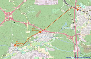
= This map was created from OpenStreetMap project data, collected by the community. This map may be incomplete, and may contain errors. Don't rely solely on it for navigation.Deutsch: Verlauf der ehemaligen Bahnstrecke Feucht-Wendelstein |
|||
| Date | (see file history) | |||
| Source | You may find a page on the OpenStreetMap wiki page for Map of Bahnstrecke Feucht-Wendelstein | |||
| Creator |
OpenStreetMap contributors |
|||
| Permission (Reusing this file) |
OpenStreetMap data is available under the Open Database License (details). Standard style map tiles are licensed as ODbL Produced Works.
|
|||
| Georeferencing | If inappropriate please set warp_status = skip to hide. |
File history
Click on a date/time to view the file as it appeared at that time.
| Date/Time | Thumbnail | Dimensions | User | Comment | |
|---|---|---|---|---|---|
| current | 04:58, 13 June 2018 | | 1,025 × 666 (147 KB) | Derzno (talk | contribs) | |
| 05:23, 7 June 2018 |  | 1,312 × 758 (156 KB) | Derzno (talk | contribs) | {{Information |description ={{de|1=Verlauf der ehemalisgen Bahnstrecke Feucht-Wendelstein}} |source ={{own}} |author =User:Derzno |date = }} |
You cannot overwrite this file.
File usage on Commons
The following 9 pages use this file:
- User:Chumwa/OgreBot/Potential transport maps/2018 June 1-10
- User:Chumwa/OgreBot/Potential transport maps/2018 June 11-20
- User:Chumwa/OgreBot/Public transport information/2018 June 1-10
- User:Chumwa/OgreBot/Public transport information/2018 June 11-20
- User:Chumwa/OgreBot/Transport Maps/2018 June 1-10
- User:Chumwa/OgreBot/Transport Maps/2018 June 11-20
- User:Chumwa/OgreBot/Travel and communication maps/2018 June 1-10
- User:Chumwa/OgreBot/Travel and communication maps/2018 June 11-20
- Category:Bahnstrecke Feucht–Wendelstein
File usage on other wikis
The following other wikis use this file:
- Usage on de.wikipedia.org
- Usage on www.wikidata.org