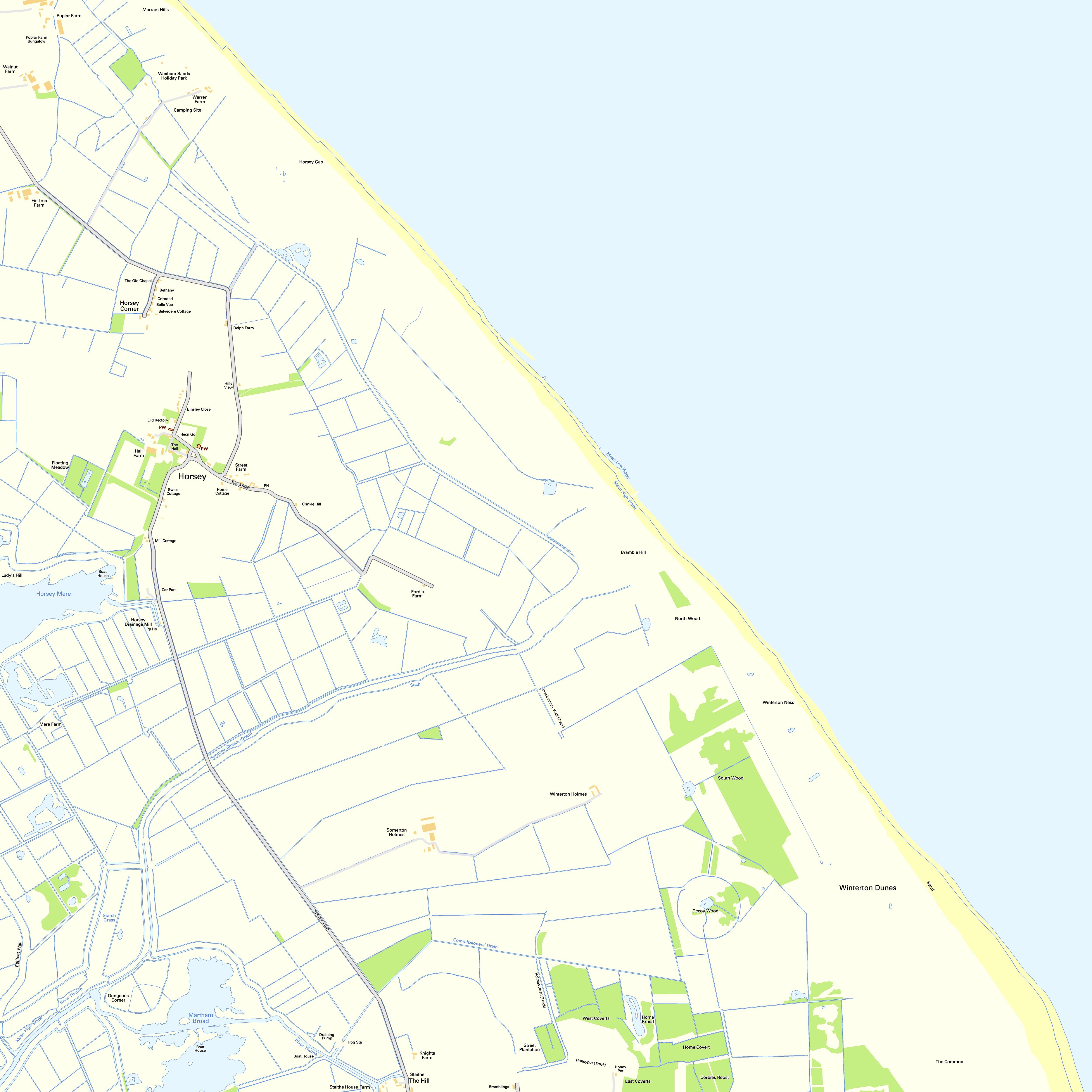
File:OS Street View TG42SE.jpg
Size of this preview: 600 × 600 pixels. Other resolutions: 240 × 240 pixels | 480 × 480 pixels | 768 × 768 pixels | 1,024 × 1,024 pixels | 2,048 × 2,048 pixels | 5,000 × 5,000 pixels.
Original file (5,000 × 5,000 pixels, file size: 1.97 MB, MIME type: image/jpeg)
Captions
Captions
Add a one-line explanation of what this file represents
Summary
edit
| Description |
Español: Un mapa de la Ordnance Survey de la zona TG42SE del sistema de referencia británico. Français : Une carte de l'Ordnance Survey de la zone TG42SE dans le système de référence britanique. Italiano: Una carta della Ordnance Survey della zona TG42SE nella sistema di referenza britannica.         |
| Date | 17 July 2010 (upload date) |
| Source | Ordnance Survey OpenData Ordnance Survey Street View. Converted from File:OS Street View TG42SE.tif to jpg |
| Author | Ordnance Survey |
Licensing
edit
This file is licensed by the Ordnance Survey of the United Kingdom under their OS OpenData License
In short: you are free to distribute and modify the file as long as you attribute (including year), the Ordnance Survey. Attribution: Contains Ordnance Survey data © Crown copyright and database right (year) Note: Derivative works can be licensed under any Creative Commons Attribution 3.0 Licence. |
_(St_Edwards_Crown).svg)
|
This file is licensed under the United Kingdom Open Government Licence v3.0. |
See also: Meta for information on usage on Wikimedia wikis.
|
File history
Click on a date/time to view the file as it appeared at that time.
| Date/Time | Thumbnail | Dimensions | User | Comment | |
|---|---|---|---|---|---|
| current | 21:30, 17 July 2010 | | 5,000 × 5,000 (1.97 MB) | OrdnanceSurveyBot (talk | contribs) | {{subst:Commons:Batch uploading/Ordnance Survey/Template |subst=subst: |square=TG42SE |scale= |sourcename=Ordnance Survey Street View |basefilename=OS Street View |extension=jpg |nw_square=TG42NW |n_square=TG42NE |ne_square= |w_square=TG42SW |e_square= | |
You cannot overwrite this file.
File usage on Commons
The following 14 pages use this file:
- File:OS Street View TG41NE.jpg
- File:OS Street View TG41NE.tif
- File:OS Street View TG41NW.jpg
- File:OS Street View TG41NW.tif
- File:OS Street View TG42NE.jpg
- File:OS Street View TG42NE.tif
- File:OS Street View TG42NW.jpg
- File:OS Street View TG42NW.tif
- File:OS Street View TG42SE.jpg
- File:OS Street View TG42SE.tif
- File:OS Street View TG42SW.jpg
- File:OS Street View TG42SW.tif
- File:OS Street View TG51NW.jpg
- File:OS Street View TG51NW.tif