File:OS map Eddington Kent 1959 2 005.jpg

Size of this preview: 800 × 579 pixels. Other resolutions: 320 × 232 pixels | 640 × 463 pixels | 1,024 × 741 pixels | 1,280 × 926 pixels | 2,560 × 1,853 pixels | 6,774 × 4,903 pixels.
Original file (6,774 × 4,903 pixels, file size: 6.13 MB, MIME type: image/jpeg)
Captions
Captions
Add a one-line explanation of what this file represents
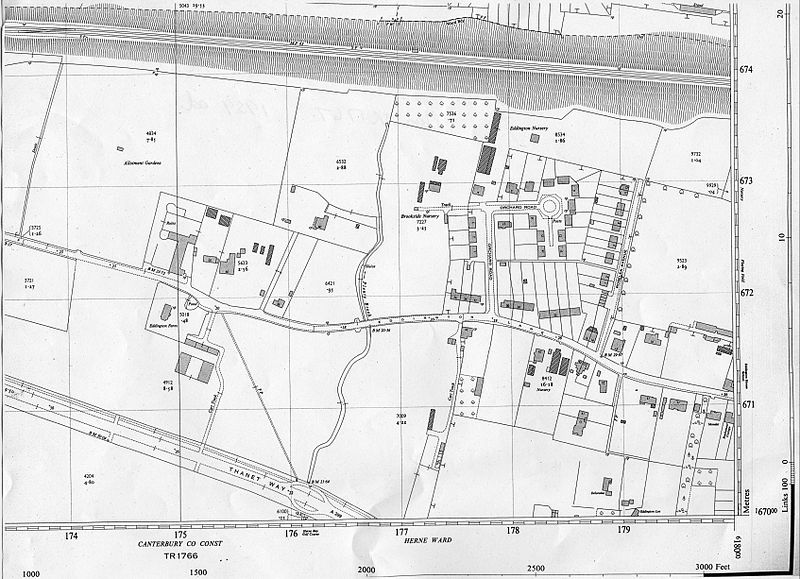
| Description | Part of 1959 OS map, scale 1:2500 or 25.344 inches to 1 mile (Plan TR1867) of Eddington in East Kent, England. Showing the west side of Eddington, and part of Eddington's northern edge along the railway line. Running south-north through the centre is Plenty Brook which then runs north through a culvert under Herne Bay to the sea. To the west of Plenty Brook is Eddington Farm: its farmland now lies under the postal sorting office and business park. |
| Date | |
| Source | Scan of photocopy of original map |
| Author | Ordnance Survey |
| Permission (Reusing this file) |
copyright expired |
| Other versions |
Other old OS maps of this area: |
This work is an Ordnance Survey map over 50 years old, which is covered by Crown Copyright which in this case expires 50 years after publication. Ordnance Survey does however ask that they be credited and that the date of publication be given.
Any ancillary rights gained through the creation of the electronic version are granted as freely usable under any circumstances.
|
This work created by the United Kingdom Government is in the public domain.
This is because it is one of the following:
HMSO has declared that the expiry of Crown Copyrights applies worldwide (ref: HMSO Email Reply)
|
 |
File history
Click on a date/time to view the file as it appeared at that time.
| Date/Time | Thumbnail | Dimensions | User | Comment | |
|---|---|---|---|---|---|
| current | 14:21, 4 February 2011 | | 6,774 × 4,903 (6.13 MB) | Storye book (talk | contribs) | {{Information |Description=Part of 1959 OS map, scale 1:2500 or 25.344 inches to 1 mile (Plan TR1867) of Eddington in East Kent, England. Showing the west side of Eddington, and part of Eddington's northern edge along the railway line. Running sou |
You cannot overwrite this file.
File usage on Commons
There are no pages that use this file.
File usage on other wikis
The following other wikis use this file:
- Usage on en.wikipedia.org