File:Obcine Slovenija 2007 4col.svg

Size of this PNG preview of this SVG file: 800 × 522 pixels. Other resolutions: 320 × 209 pixels | 640 × 418 pixels | 1,024 × 668 pixels | 1,280 × 835 pixels | 2,560 × 1,670 pixels | 2,613 × 1,705 pixels.
Original file (SVG file, nominally 2,613 × 1,705 pixels, file size: 2.36 MB)
Captions
Captions
Add a one-line explanation of what this file represents
Summary
edit| Description |
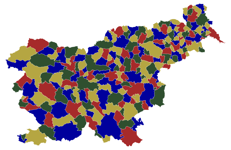
English: Map of the municipalities (občine) of the Republic of Slovenia, as since May 2006 (210 units), colored by 4 colors. Note that there are 210 municipalities, but there are 212 regions on this map, since the Zagorje ob Savi municipality and Gorenja vas - Poljane municipality have exclaves south of the main part. Although with this stricter restriction the 210-vertex graph was non-planar, it was fortunately still 4-colorable. So this is both an example of the 4 color theorem for 212 regions, and valid 4-color map for Slovenian municipalities. |
| Date | |
| Source | Source of the public data is GURS (Geodetska uprava Republike Slovenije or Surveying and Mapping Authority of the Republic of Slovenia). Converted from Shapefile to SVG with shp2svg and prepared for Wikipedia, input matrix prepared from SVG adjacency points, then fed to the A. Dharwadker's Vertex Coloring Algorithm which produced text output, which was incorporated back to SVG by romanm (talk). |
| Author | See above. |
| Permission (Reusing this file) |
Public domain. See Image:Obcine Slovenija 2006.svg for an explanation. |
| Other versions |
|


Licensing
edit
| I, the copyright holder of this work, release this work into the public domain. This applies worldwide. In some countries this may not be legally possible; if so: I grant anyone the right to use this work for any purpose, without any conditions, unless such conditions are required by law. |
File history
Click on a date/time to view the file as it appeared at that time.
| Date/Time | Thumbnail | Dimensions | User | Comment | |
|---|---|---|---|---|---|
| current | 21:40, 18 July 2009 | | 2,613 × 1,705 (2.36 MB) | Romanm (talk | contribs) | {{Information |Description=Map of the municipalities (občine) of the Republic of Slovenia, as since May 2006 (210 units), color by 4 colors. |Source=Source of [http://www.gu.gov.si/si/delovnapodrocja_gu/podatki_gu/brezplani_podatki/brezplani_podatki_obin |
You cannot overwrite this file.
File usage on Commons
There are no pages that use this file.