File:OberlaudenbachKarte.png

Size of this preview: 567 × 599 pixels. Other resolutions: 227 × 240 pixels | 454 × 480 pixels | 707 × 747 pixels.
Original file (707 × 747 pixels, file size: 19 KB, MIME type: image/png)
Captions
Captions
Add a one-line explanation of what this file represents
| Description |
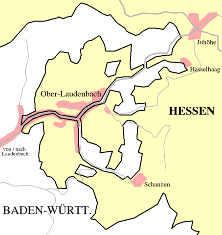
Deutsch: Grenzziehung zwischen Baden-Württemberg und Hessen bei Ober-Laudenbach
English: Border between the German states of Baden-Württemberg and Hesse near Ober-Laudenbach |
||||||||
| Date | |||||||||
| Source | Own work | ||||||||
| Author | Ssch | ||||||||
| Permission (Reusing this file) |
|

File history
Click on a date/time to view the file as it appeared at that time.
| Date/Time | Thumbnail | Dimensions | User | Comment | |
|---|---|---|---|---|---|
| current | 10:52, 3 December 2006 | | 707 × 747 (19 KB) | Ssch~commonswiki (talk | contribs) | {{Information| |Description =<br/> *de : Grenzziehung zwischen Baden-Württemberg und Hessen bei Ober-Laudenbach |Source = drawn by myself |Date = December 2006 |Author = Ssch |Permission = {{GFDL}} |other_versions = |
You cannot overwrite this file.
File usage on Commons
The following 3 pages use this file:
File usage on other wikis
The following other wikis use this file:
- Usage on azb.wikipedia.org
- Usage on de.wikipedia.org
- Usage on ja.wikipedia.org