File:Obermillstatt OpenStreetMap 180224.jpg

Size of this preview: 799 × 599 pixels. Other resolutions: 320 × 240 pixels | 640 × 480 pixels | 1,013 × 760 pixels.
Original file (1,013 × 760 pixels, file size: 453 KB, MIME type: image/jpeg)
Captions
Captions
Add a one-line explanation of what this file represents
Summary
edit
| Description |
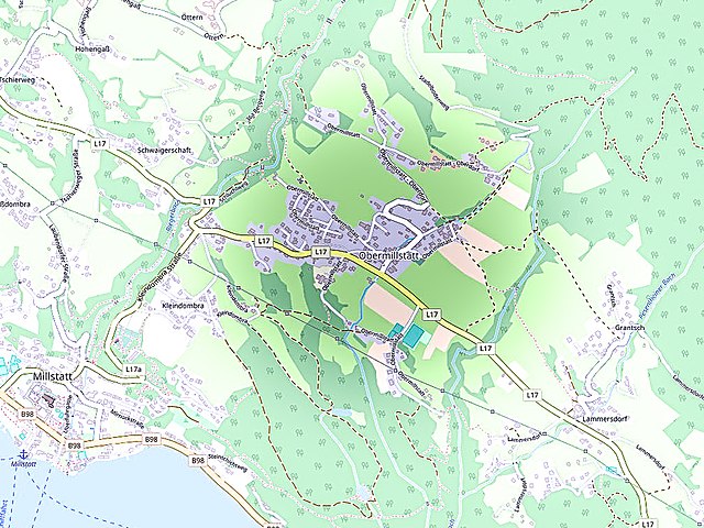
Deutsch: Diese (noch nicht ganz vollständige) Karte (Stand 24. Februar 2018) des offen Kartenerstellungsprojekts OpenStreetMap zeigt links die Oberkärntner Ort Obermillstatt oberhalb des Millstätter Sees am Millstätter Berg.
Diese Karte entstammt dem offenen OpenStreetMap Projekt, erstellt von der Community. Diese Karte kann unvollständig sein oder Fehler enthalten. Verlasse dich in Navigationsfragen nicht alleine darauf. English: This map was created from OpenStreetMap project data, collected by the community. This map may be incomplete, and may contain errors. Don't rely solely on it for navigation.
Español: Este mapa fue creado con los datos del proyecto OpenStreetMap, obtenidos por la comunidad. Este mapa puede estar incompleto, y puede contener errores. No se fíe solamente en él para las navegaciones.
Français : Cette carte a été créée à partir des données du projet OpenStreetMap. Cette carte est peut-être incomplète et peut contenir des erreurs. Ne vous fiez pas uniquement à elle pour vos déplacements.
Italiano: Questa mappa è stata creata con dati raccolti dal progetto OpenStreetMap. La mappa potrebbe essere incompleta e contenere errori. Non affidarsi esclusivamente ad essa per la navigazione. |
| Date | see file history |
| Source | www.openstreetmap.org |
| Author | OpenStreetMap contributors Obermillstatt |
| Permission (Reusing this file) |
All OpenStreetMap data and maps are Creative Commons "CC-BY-SA 2.0" licensed This file is licensed under the Creative Commons Attribution-Share Alike 2.0 Generic license.
|
| Camera location | | View this and other nearby images on: OpenStreetMap |
|---|
File history
Click on a date/time to view the file as it appeared at that time.
| Date/Time | Thumbnail | Dimensions | User | Comment | |
|---|---|---|---|---|---|
| current | 22:37, 24 February 2018 | | 1,013 × 760 (453 KB) | Joadl (talk | contribs) | anderes Format |
| 22:29, 24 February 2018 |  | 649 × 845 (358 KB) | Joadl (talk | contribs) | {{Information |Description= {{de|Diese (noch nicht ganz vollständige) Karte (Stand 5. Mai 2012) des offen Kartenerstellungsprojekts OpenStreetMap zeigt links die Oberkärntner Stadt Spittal an der Drau, die Tauernautobahn A10, das Drautal, den Millstätter See und darüber den Millstätter Berg. Folgende Ortsbezeichnungen scheinen auf: Treffling, Kolm, Kötzing, Kras Unterhaus, Muskanitzen, Liedweg, Tangern, Lieserbrücke, Lurnbichl, Seeboden, Obedorf Edling, Stankt Wolfgang, Gössering, Laubendorf, Schwaigerschaft, Hohengaß, Tschierweg, Großdombrad, Kleindombra, Lechnerschaft, Millstatt, Obermillstatt, Grantsch, Lammersdorf, Sappl, Matzelsdorf, Laufenberg, Dellach, Döbriach, Pesenthein, Glanz, Erdmannsiedlung, Rothenthurn, Olsach, Nußdorf, Winkl, Großegg, Oberdorf, Tiroler Straße, Sankt Wolfgang, Wolfsberg, Edlinger Straße, Kreiselsdorf, Zgurn, Baldersdorf, Schüttbach, Tangern, Sankt Peter, Oberamlach, Unteramlach, Winkl, Großegg, TRothenthurn, Olsach, Neuolsach, I... |
You cannot overwrite this file.
File usage on Commons
The following page uses this file:
File usage on other wikis
The following other wikis use this file:
- Usage on de.wikipedia.org
- Usage on www.wikidata.org