File:Oceania political map.png
No higher resolution available.
Oceania_political_map.png (662 × 478 pixels, file size: 42 KB, MIME type: image/png)
Captions
Captions
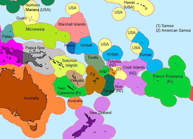
Political map of Oceania (EEZ borders)
Summary edit
| Description |
English: Political map of Oceania (EEZ borders)
Français : Carte politique de l'Océanie (frontières des ZEE) |
| Date | |
| Source | Based on a cropped section of Exclusive Economic Zones World Pacific-centric.png |
| Author | ព្រះមហាក្សត្ររាជ |
Licensing edit
I, the copyright holder of this work, hereby publish it under the following license:
This file is licensed under the Creative Commons Attribution-Share Alike 4.0 International license.
- You are free:
- to share – to copy, distribute and transmit the work
- to remix – to adapt the work
- Under the following conditions:
- attribution – You must give appropriate credit, provide a link to the license, and indicate if changes were made. You may do so in any reasonable manner, but not in any way that suggests the licensor endorses you or your use.
- share alike – If you remix, transform, or build upon the material, you must distribute your contributions under the same or compatible license as the original.
File history
Click on a date/time to view the file as it appeared at that time.
| Date/Time | Thumbnail | Dimensions | User | Comment | |
|---|---|---|---|---|---|
| current | 02:31, 1 February 2022 | | 662 × 478 (42 KB) | ព្រះមហាក្សត្ររាជ (talk | contribs) | Color changes |
| 02:22, 1 February 2022 |  | 662 × 478 (42 KB) | ព្រះមហាក្សត្ររាជ (talk | contribs) | Color changes | |
| 23:45, 31 January 2022 |  | 662 × 478 (42 KB) | ព្រះមហាក្សត្ររាជ (talk | contribs) | Uploaded own work with UploadWizard |
You cannot overwrite this file.
File usage on Commons
There are no pages that use this file.
File usage on other wikis
The following other wikis use this file:
- Usage on en.wikipedia.org
- Usage on id.wikipedia.org