File:Ochsental12.jpg

Size of this preview: 450 × 600 pixels. Other resolutions: 180 × 240 pixels | 360 × 480 pixels | 576 × 768 pixels | 768 × 1,024 pixels | 2,112 × 2,816 pixels.
Original file (2,112 × 2,816 pixels, file size: 3.13 MB, MIME type: image/jpeg)
Captions
Captions
Add a one-line explanation of what this file represents
Summary
edit
| Description |
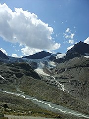
English: The Silvretta Reservoir is situated in the westernmost federal state Vorarlberg of Austria. From there the Ochsental runs south among the Silvretta Alps. Deutsch: Der Silvretta-Stausee liegt im Bundesland Vorarlberg im äußersten Westen Österreichs. Von hier ausgehend verläuft das Ochsental nach Süden. Im Bild: Blick ans Ende des Ochsentals zu den Silvretta-Alpen. |
| Date | |
| Source | Own work |
| Author | Nikater |
| Permission (Reusing this file) |
Own work, all rights released (Public domain) |
| Camera location | | View this and other nearby images on: OpenStreetMap |
|---|
Licensing
edit
| I, the copyright holder of this work, release this work into the public domain. This applies worldwide. In some countries this may not be legally possible; if so: I grant anyone the right to use this work for any purpose, without any conditions, unless such conditions are required by law. |
| Annotations | This image is annotated: View the annotations at Commons |
File history
Click on a date/time to view the file as it appeared at that time.
| Date/Time | Thumbnail | Dimensions | User | Comment | |
|---|---|---|---|---|---|
| current | 12:26, 1 May 2012 | | 2,112 × 2,816 (3.13 MB) | Nikater (talk | contribs) | == {{int:filedesc}} == {{Information |Description={{en|1=The Silvretta Reservoir is situated in the westernmost federal state Vorarlberg of Austria. From there the Ochsental runs south among the Silvretta Alps.}} {{de|1=Der [[:d... |
You cannot overwrite this file.
File usage on Commons
There are no pages that use this file.