File:Odenwaldeinteilung.png
Size of this preview: 610 × 599 pixels. Other resolutions: 244 × 240 pixels | 489 × 480 pixels | 895 × 879 pixels.
Original file (895 × 879 pixels, file size: 1.53 MB, MIME type: image/png)
Captions
Captions
Add a one-line explanation of what this file represents
Summary
edit
| Description |
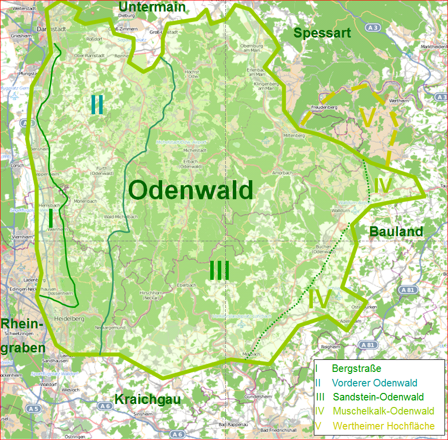
Deutsch: Die in etwa Grenzen des Odenwaldes und seiner Einteilungen; diese stimmen nicht exakt mit den naturräumlichen Gliederungen überein, sondern sind durch historische und politische Grenzen bestimmt. Die Wertheimer Hochfläche zum Beispiel (gestrichelte Grenzen im Osten) gehört naturräumlich zum Spessart, wird aber geografisch zum Odenwald gezählt; die Bergstraße historisch zum Odenwald zählend, hat sich politisch seit der Neuzeit verselbständigt, ist aber natur-räumlich (geografisch) eigentlich Teil des Odenwaldes; das Bauland war bis zur Neuzeit geografisch und politisch zum Odenwald gezählt. |
| Date | |
| Source |
Commander-pirx; Deutsch: Hintergrund basiert auf Open Street Map; Orts- und Linienangaben aus verschiedenen Quellen |
| Author | Commander-pirx |
Licensing
edit
| This work contains information from OpenStreetMap, which is made available under the Open Database License (ODbL).
The ODbL does not require any particular license for maps produced from ODbL data. Prior to 1 August 2020, map tiles produced by the OpenStreetMap Foundation were licensed under the CC-BY-SA-2.0 license. Maps produced by other people may be subject to other licences. |
Commander-pirx at German Wikipedia, the copyright holder of this work, hereby publishes it under the following licenses:

|
Permission is granted to copy, distribute and/or modify this document under the terms of the GNU Free Documentation License, Version 1.2 or any later version published by the Free Software Foundation; with no Invariant Sections, no Front-Cover Texts, and no Back-Cover Texts. A copy of the license is included in the section entitled GNU Free Documentation License. |
This file is licensed under the Creative Commons Attribution-Share Alike 3.0 Unported license.
Attribution: Commander-pirx at German Wikipedia
- You are free:
- to share – to copy, distribute and transmit the work
- to remix – to adapt the work
- Under the following conditions:
- attribution – You must give appropriate credit, provide a link to the license, and indicate if changes were made. You may do so in any reasonable manner, but not in any way that suggests the licensor endorses you or your use.
- share alike – If you remix, transform, or build upon the material, you must distribute your contributions under the same or compatible license as the original.
This file is licensed under the Creative Commons Attribution-Share Alike 3.0 Germany license.
Attribution: Commander-pirx at German Wikipedia
- You are free:
- to share – to copy, distribute and transmit the work
- to remix – to adapt the work
- Under the following conditions:
- attribution – You must give appropriate credit, provide a link to the license, and indicate if changes were made. You may do so in any reasonable manner, but not in any way that suggests the licensor endorses you or your use.
- share alike – If you remix, transform, or build upon the material, you must distribute your contributions under the same or compatible license as the original.

You may select the license of your choice.
Original upload log
edit
The original description page was here. All following user names refer to de.wikipedia.
- 2014-06-12 18:41 Commander-pirx 895×879× (1608429 bytes) {{Information |Beschreibung = Die in etwa Grenzen des [[Odenwald]]es und seiner Einteilungen; diese stimmen nicht exakt mit den naturräumlichen Gliederungen überein, sondern sind durch historische und politische Grenzen bestimmt. Die Wertheimer H…
File history
Click on a date/time to view the file as it appeared at that time.
| Date/Time | Thumbnail | Dimensions | User | Comment | |
|---|---|---|---|---|---|
| current | 06:25, 18 June 2014 | | 895 × 879 (1.53 MB) | Nachcommonsverschieber (talk | contribs) | Transferred from de.wikipedia |
You cannot overwrite this file.
File usage on Commons
There are no pages that use this file.
File usage on other wikis
The following other wikis use this file:
- Usage on de.wikipedia.org
- Usage on nl.wikipedia.org