File:Odoi aerial.jpg
Size of this preview: 800 × 444 pixels. Other resolutions: 320 × 178 pixels | 640 × 355 pixels | 1,178 × 654 pixels.
Original file (1,178 × 654 pixels, file size: 142 KB, MIME type: image/jpeg)
Captions
Captions
Add a one-line explanation of what this file represents
Summary
edit
en
edit
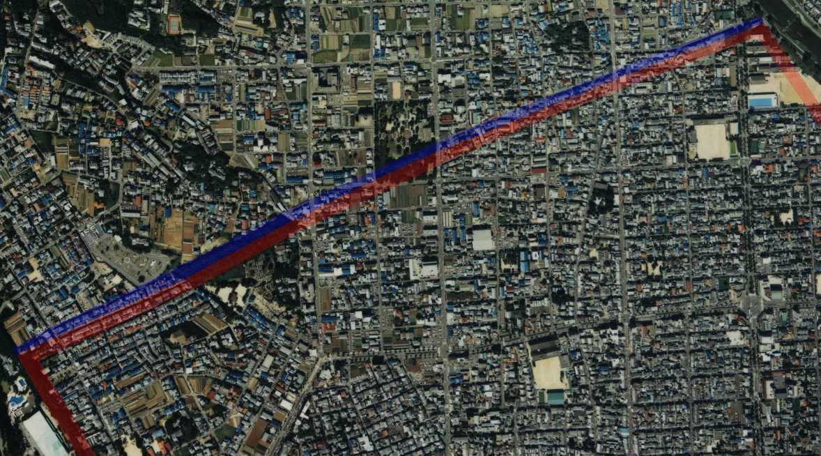
- Description: drew the site of Odoi, a barrier(red) and a moar(blue) on the aerial photo of Kyoto, Japan.
- Source: image from Country Picture Information (Color Aerial Photo) archive copy at the Wayback Machine resized and drew by Matsukaze.
- Date: 1988
ja
edit
- 説明: 京都市の航空写真に御土居(赤)と堀(青)の跡を描いた。
- 出典: 国土画像情報 (カラー空中写真) archive copy at the Wayback Machineの写真を元にMatsukazeにより編集・作成。
Licensing
edit

|
The copyright holder of this file, the Ministry of Land, Infrastructure, Transport and Tourism of Japan, allows anyone to use it for any purpose, provided that the copyright holder is properly attributed. Redistribution, derivative work, commercial use, and all other use is permitted. |
Attribution:
Copyright © National Land Image Information (Color Aerial Photographs), Ministry of Land, Infrastructure, Transport and Tourism
|
 |
This image is copyrighted by the Ministry of Land, Infrastructure, Transport and Tourism of Japan. For terms of use, see the stipulation to use of National Land Information (in Japanese) and message from MLIT (in Japanese and English). When you display this image on an article, include the following phrase in the description: "Made based on National Land Image Information (Color Aerial Photographs), Ministry of Land, Infrastructure, Transport and Tourism".
|
File history
Click on a date/time to view the file as it appeared at that time.
| Date/Time | Thumbnail | Dimensions | User | Comment | |
|---|---|---|---|---|---|
| current | 09:15, 23 July 2006 | | 1,178 × 654 (142 KB) | Matsukaze (talk | contribs) | == en == *'''Description:''' drew the site of Odoi, a barrier(red) and a moar(blue) on the aerial photo of Kyoto, Japan. *'''Source:''' image from [http://w3land.mlit.go.jp/WebGIS/ Country Picture Information (Color Aerial Photo)] resized and drew by [[Us |
You cannot overwrite this file.
File usage on Commons
There are no pages that use this file.
File usage on other wikis
The following other wikis use this file:
- Usage on fr.wikipedia.org
- Usage on ja.wikipedia.org