File:Ogilby and Morgan Map of London 1677 BL Maps Crace Port 2 61.jpg

Size of this preview: 800 × 456 pixels. Other resolutions: 320 × 182 pixels | 640 × 365 pixels | 1,024 × 584 pixels | 1,280 × 730 pixels | 2,000 × 1,140 pixels.
Original file (2,000 × 1,140 pixels, file size: 627 KB, MIME type: image/jpeg)
Captions
Captions
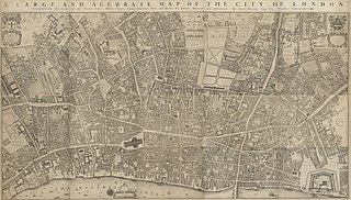
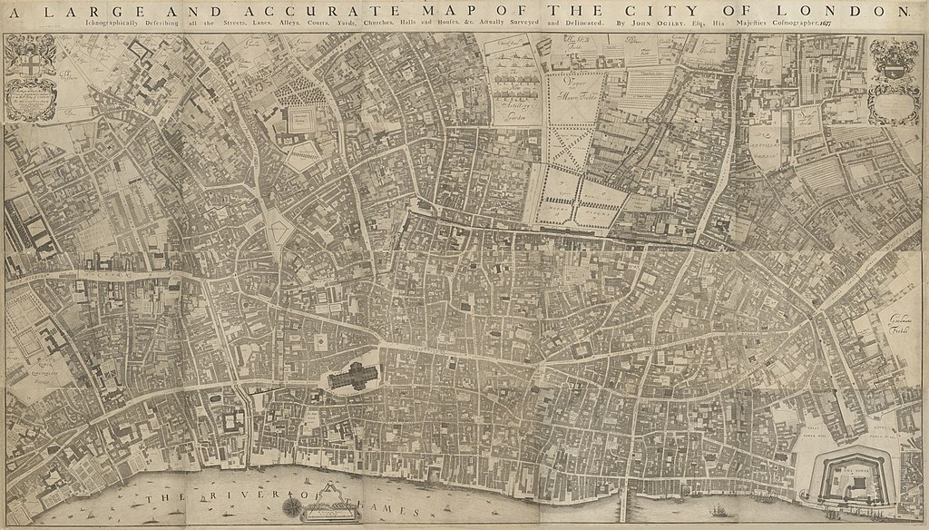
Original 20 sheet edition of Ogilby and Morgan map of London 1677
Summary
edit| A large and accurate map of the city of London
|
||||||||||||||||||||||||||||||||||||||||||||||||||||||||||||
|---|---|---|---|---|---|---|---|---|---|---|---|---|---|---|---|---|---|---|---|---|---|---|---|---|---|---|---|---|---|---|---|---|---|---|---|---|---|---|---|---|---|---|---|---|---|---|---|---|---|---|---|---|---|---|---|---|---|---|---|---|
| Artist |
|
 | ||||||||||||||||||||||||||||||||||||||||||||||||||||||||||
| Title |
A large and accurate map of the city of London |
|||||||||||||||||||||||||||||||||||||||||||||||||||||||||||
| Object type |
individual copy of a map |
|||||||||||||||||||||||||||||||||||||||||||||||||||||||||||
| Language |
English |
|||||||||||||||||||||||||||||||||||||||||||||||||||||||||||
| Publication date |
1677 |
|||||||||||||||||||||||||||||||||||||||||||||||||||||||||||
| Collection | ||||||||||||||||||||||||||||||||||||||||||||||||||||||||||||
| Accession number |
Crace Port. 2.61 (British Library) |
|||||||||||||||||||||||||||||||||||||||||||||||||||||||||||
| Source/Photographer |
|
|||||||||||||||||||||||||||||||||||||||||||||||||||||||||||

.jpg)


Licensing
edit
|
This is a faithful photographic reproduction of a two-dimensional, public domain work of art. The work of art itself is in the public domain for the following reason:
The official position taken by the Wikimedia Foundation is that "faithful reproductions of two-dimensional public domain works of art are public domain".
This photographic reproduction is therefore also considered to be in the public domain in the United States. In other jurisdictions, re-use of this content may be restricted; see Reuse of PD-Art photographs for details. | ||||
File history
Click on a date/time to view the file as it appeared at that time.
| Date/Time | Thumbnail | Dimensions | User | Comment | |
|---|---|---|---|---|---|
| current | 21:10, 24 June 2021 | | 2,000 × 1,140 (627 KB) | PKM (talk | contribs) | {{Artwork |Wikidata = Q107339633 |Source = {{British Library image |url=https://www.bl.uk/collection-items/a-large-and-accurate-map-of-the-city-of-london |ms-shelfmark=T |cim-msid= |cim-coll= |cim-nstart= |dips=|ms-digi= |hasLicense=yes}} }} == {{int:license-header}} == {{PD-art|PD-old-100}} Category:Old maps of London Category:Maps by John Ogilby Category:William Morgan (cartographer) Category:Maps by Wenzel Hollar |
You cannot overwrite this file.
File usage on Commons
The following page uses this file:
File usage on other wikis
The following other wikis use this file:
- Usage on www.wikidata.org