File:Oil fires, gas flares, and fires in the Middle East (MODIS 2016-10-17).jpg

Original file (5,000 × 6,400 pixels, file size: 4.14 MB, MIME type: image/jpeg)
Captions
Captions
Summary
edit.jpg&action=edit§ion=1)
| Description |
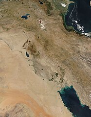
English: On October 9, 2016, the Moderate Resolution Imaging Spectroradiometer (MODIS) on NASA’s Terra satellite captured this true-color image of oil fires, gas flares, and fires across the Middle East.
Each red hotspot marks an area where the thermal sensors on the MODIS instrument detected an area where temperatures were notably higher than background. Hotspots scattered across the landscape are often indicative of actively burning fires, but in fact they can be caused by a variety of heat sources. In many cases, additional features seen in images can help identify the source. Vegetation fires (forest fires, bushfire, grassfires and similar) generally burn with gray smoke, so a hotspot combined with gray smoke indicates an actively burning fire. Several such fires can be seen in the northern section of the image, scattered in the light green areas of Turkey and northern Iran. The smoke is best viewed at high resolution. Further south, thick, oily-black smoke rises from a number of hotspots north of Thertar Lake in Iran. This oily-appearing smoke is typical of oil fires. A number of oil wells and storage facilities are located in this area. Oil fires have significant impact on human health and the environment, and have become all too common in oil-rich regions suffering violent conflicts. These fires cluster northwest in an area where war rages as Iraqi Security Forces and an International Coalition (CJTR-OIH) attempt to retake the area from ISIL. Oil facilities have become targets in war, and also can be unintentionally damaged. In the south of the image, small hotspots can be seen aligned in a linear fashion in the Fertile Crescent north of the Persian Gulf. There is no visible smoke from these hotspots. While it is difficult to know for certain, these are likely marking gas flares. These are flames produced by a device that allows the burning off of flammable gas produced by pressure relief valves or planned, controlled, combustion. Such fires burn in small areas, do not spread (as natural fires would as they consume fuel) and produce almost no smoke. |
||
| Date | Taken on 9 October 2016 | ||
| Source |
Oil fires, gas flares, and fires in the Middle East (direct link)
|
||
| Author | Jeff Schmaltz, MODIS Land Rapid Response Team, NASA GSFC |
| This media is a product of the Terra mission Credit and attribution belongs to the mission team, if not already specified in the "author" row |
Licensing
edit.jpg&action=edit§ion=2)
| This file is in the public domain in the United States because it was solely created by NASA. NASA copyright policy states that "NASA material is not protected by copyright unless noted". (See Template:PD-USGov, NASA copyright policy page or JPL Image Use Policy.) | ||
 |
Warnings:
|
File history
Click on a date/time to view the file as it appeared at that time.
| Date/Time | Thumbnail | Dimensions | User | Comment | |
|---|---|---|---|---|---|
| current | 19:17, 15 February 2024 | | 5,000 × 6,400 (4.14 MB) | OptimusPrimeBot (talk | contribs) | #Spacemedia - Upload of http://modis.gsfc.nasa.gov/gallery/images/image10172016_250m.jpg via Commons:Spacemedia |
You cannot overwrite this file.
File usage on Commons
There are no pages that use this file.
.jpg&oldid=852066624)