File:Oker in Wolfenbuettel OSM 1741 765px.jpg

Size of this preview: 600 × 600 pixels. Other resolutions: 240 × 240 pixels | 480 × 480 pixels | 765 × 765 pixels.
Original file (765 × 765 pixels, file size: 347 KB, MIME type: image/jpeg)
Captions
Captions
Add a one-line explanation of what this file represents
Summary edit
| Description |
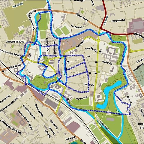
English: Oker in Wolfenbuettel today and 1741 without bastions.
Deutsch: Oker in Wolfenbüttel, schraffiert der ungefähre Verlauf von 1741 ohne die Festungsgräben. |
| Date | |
| Source | Openstreetmap.org 2015 und Ludwig August Faber: PROPORTIONAL Grundriß der Fürstlichen Residenz Stadt und Festung Wolffenbüttel nebst daran liegendem Distrikte. Maßstab 1:3000, Niedersächsisches Staatsarchiv Wolfenbüttel K 170. |
| Author | Okernick |
Licensing edit
I, the copyright holder of this work, hereby publish it under the following licenses:

|
Permission is granted to copy, distribute and/or modify this document under the terms of the GNU Free Documentation License, Version 1.2 or any later version published by the Free Software Foundation; with no Invariant Sections, no Front-Cover Texts, and no Back-Cover Texts. A copy of the license is included in the section entitled GNU Free Documentation License. |
This file is licensed under the Creative Commons Attribution-Share Alike 3.0 Unported license.
- You are free:
- to share – to copy, distribute and transmit the work
- to remix – to adapt the work
- Under the following conditions:
- attribution – You must give appropriate credit, provide a link to the license, and indicate if changes were made. You may do so in any reasonable manner, but not in any way that suggests the licensor endorses you or your use.
- share alike – If you remix, transform, or build upon the material, you must distribute your contributions under the same or compatible license as the original.
You may select the license of your choice.
File history
Click on a date/time to view the file as it appeared at that time.
| Date/Time | Thumbnail | Dimensions | User | Comment | |
|---|---|---|---|---|---|
| current | 12:34, 25 January 2015 | | 765 × 765 (347 KB) | Okernick (talk | contribs) | {{Information |Description ={{en|1=Oker in Wolfenbuettel today and 1741 without bastions.}} {{de|1=Oker in Wolfenbüttel, schraffiert der ungefähre Verlauf von 1741 ohne die Festungsgräben.}} |Source =Openstreetmap.org 2015 und Ludwig Augu... |
You cannot overwrite this file.
File usage on Commons
There are no pages that use this file.
File usage on other wikis
The following other wikis use this file:
- Usage on de.wikipedia.org