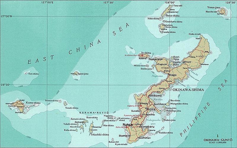
File:Okinawa-Guntō.jpg

Size of this preview: 800 × 498 pixels. Other resolutions: 320 × 199 pixels | 640 × 399 pixels | 1,135 × 707 pixels.
Original file (1,135 × 707 pixels, file size: 292 KB, MIME type: image/jpeg)
Captions
Captions
Add a one-line explanation of what this file represents
Summary edit
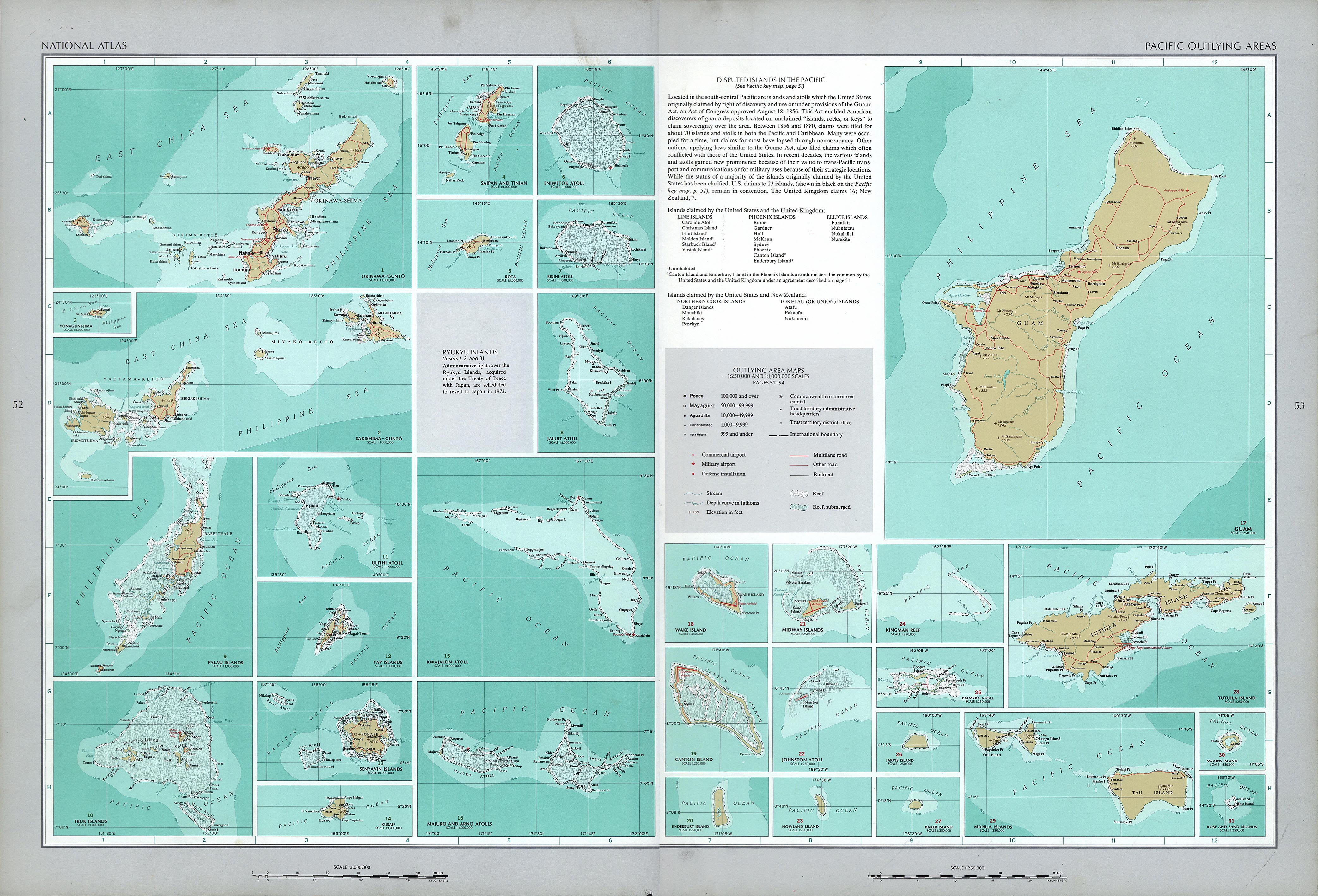
| Description |
English: National Atlas of the United States, page "Pacific Outlying Areas", with map insets:
|
| Date | |
| Source | https://www.lib.utexas.edu/maps/national_atlas_1970/ca000040.jpg |
| Author | United States Department of the Interior |
| Other versions |


Licensing edit
This work is in the public domain in the United States because it is a work prepared by an officer or employee of the United States Government as part of that person’s official duties under the terms of Title 17, Chapter 1, Section 105 of the US Code.
Note: This only applies to original works of the Federal Government and not to the work of any individual U.S. state, territory, commonwealth, county, municipality, or any other subdivision. This template also does not apply to postage stamp designs published by the United States Postal Service since 1978. (See § 313.6(C)(1) of Compendium of U.S. Copyright Office Practices). It also does not apply to certain US coins; see The US Mint Terms of Use.
|
 | |
| This file has been identified as being free of known restrictions under copyright law, including all related and neighboring rights. | ||
File history
Click on a date/time to view the file as it appeared at that time.
| Date/Time | Thumbnail | Dimensions | User | Comment | |
|---|---|---|---|---|---|
| current | 12:40, 17 October 2016 | | 1,135 × 707 (292 KB) | Mauerquadrant (talk | contribs) | Cropped 2 % horizontally and 5 % vertically using CropTool with precise mode. |
| 12:39, 17 October 2016 |  | 1,157 × 745 (312 KB) | Mauerquadrant (talk | contribs) | File:National Atlas of the USA 1970 - Pacific Outlying Areas.jpg cropped 72 % horizontally and 74 % vertically using CropTool with precise mode. |
You cannot overwrite this file.
File usage on Commons
The following 24 pages use this file:
- File:Baker Island 2.jpg
- File:Bikini Atoll 2.jpg
- File:Canton Island 2.jpg
- File:Enderbury Atoll.jpg
- File:Eniwetok Atoll.jpg
- File:Howland Island 2.jpg
- File:Jaluit Atoll.jpg
- File:Jarvis Island 2.jpg
- File:Johnston Atoll 2.jpg
- File:Kingman Reef 2.jpg
- File:Kusaie (Kosrae).jpg
- File:Kwajalein Atoll 2.jpg
- File:Majuro and Arno Atolls 2.jpg
- File:National Atlas of the USA 1970 - Pacific Outlying Areas.jpg
- File:Palau Islands.jpg
- File:Palmyra Atoll 2.jpg
- File:Sakashima-Guntō.jpg
- File:Senyavin Islands.jpg
- File:Truk Islands.jpg
- File:Truk Islands (cropped).jpg
- File:Ulithi Atoll.jpg
- File:Wake Island 2.jpg
- File:Yap Islands 2.jpg
- File:Yonaguni-Jima.jpg
.jpg)
.jpg)
File usage on other wikis
The following other wikis use this file:
- Usage on da.wikipedia.org
- Usage on en.wikipedia.org
- Usage on gl.wikipedia.org
- Usage on haw.wikipedia.org
- Usage on hu.wikipedia.org
- Usage on no.wikipedia.org
- Usage on si.wikipedia.org
- Usage on vi.wikipedia.org