File:Oklahoma minor civil divisions and townships LOC 2011590624.jpg

Size of this preview: 800 × 490 pixels. Other resolutions: 320 × 196 pixels | 640 × 392 pixels | 1,024 × 628 pixels | 1,280 × 784 pixels | 2,560 × 1,569 pixels | 13,905 × 8,522 pixels.
Original file (13,905 × 8,522 pixels, file size: 9.06 MB, MIME type: image/jpeg)
Captions
Captions
Add a one-line explanation of what this file represents
Summary edit
| Warning | The original file is very high-resolution. It might not load properly or could cause your browser to freeze when opened at full size. |
|---|
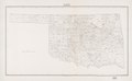
| Description |
English: "GEO. M-34-40." "U. S. Government Printing Office : 1941--0 - 304017." Available also through the Library of Congress Web site as a raster image. |
||
| Title | Oklahoma minor civil divisions and townships | ||
| Shelf ID | G4021.F7 1941 .U5 | ||
| Date | |||
| Source | https://www.loc.gov/item/2011590624/ | ||
| Author | U.S. Census Bureau | ||
| Permission (Reusing this file) |
|
||
| Other versions |
|
||
| Location | United States · Oklahoma. · Oklahoma | ||
| Part of | American Memory · General Maps · Catalog · Geography And Map Division | ||
| Subject | United States · Maps · Oklahoma · Administrative And Political Divisions |

Licensing edit
| This work is from the Library of Congress. According to the library, there are no known copyright restrictions on the use of this work. |  |
File history
Click on a date/time to view the file as it appeared at that time.
| Date/Time | Thumbnail | Dimensions | User | Comment | |
|---|---|---|---|---|---|
| current | 11:02, 26 May 2019 | | 13,905 × 8,522 (9.06 MB) | Fæ (talk | contribs) | LOC Maps https://www.loc.gov/item/2011590624/ #11129 |
You cannot overwrite this file.
File usage on Commons
The following page uses this file: