File:Okres zilina.png
Size of this preview: 790 × 600 pixels. Other resolutions: 316 × 240 pixels | 632 × 480 pixels | 1,012 × 768 pixels | 1,280 × 972 pixels | 2,376 × 1,804 pixels.
Original file (2,376 × 1,804 pixels, file size: 299 KB, MIME type: image/png)
Captions
Captions
Add a one-line explanation of what this file represents
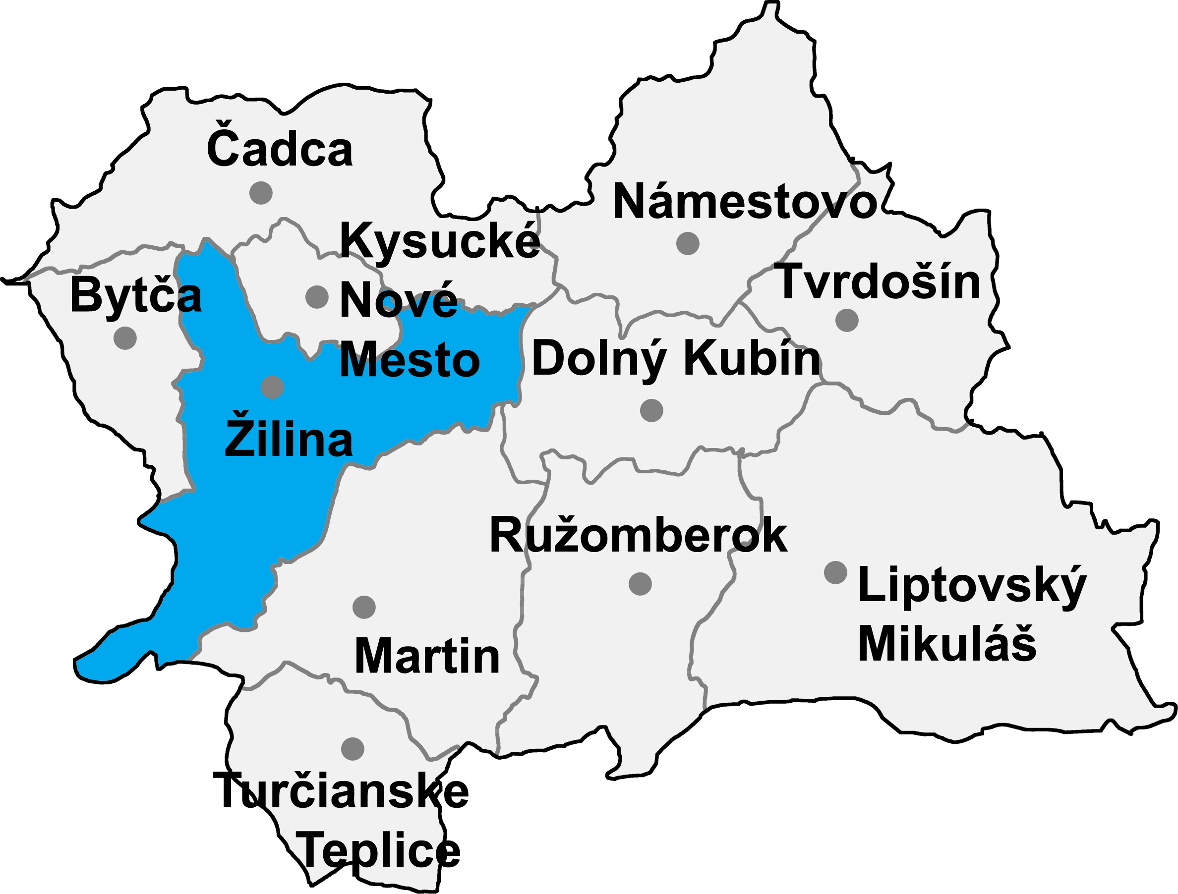
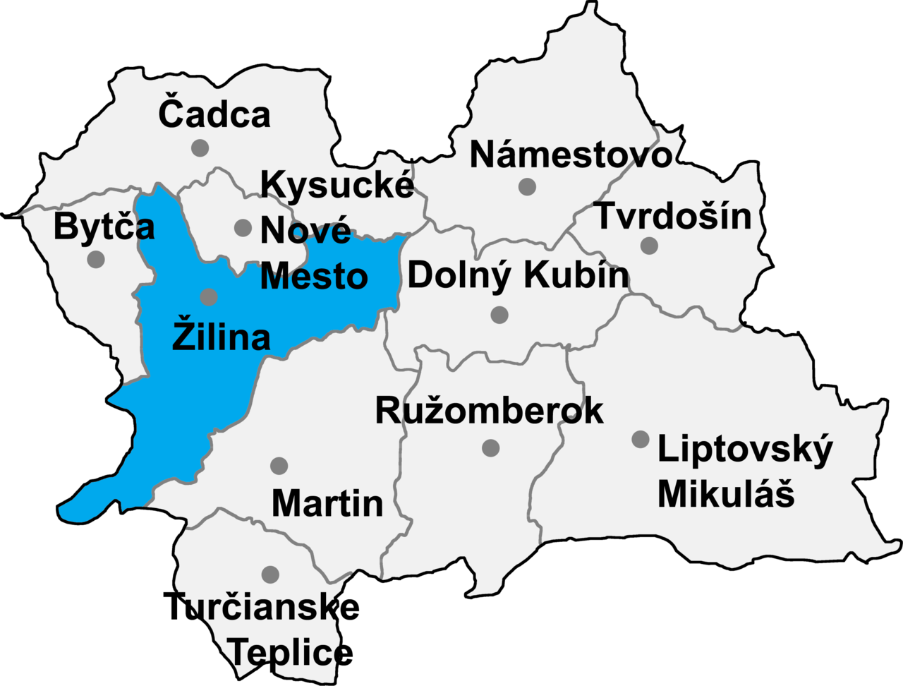
- map of the Žilina region (Žilinský kraj) in Slovakia, district (okres) of Žilina highlighted
- selfprovided on September 20th, 2004

|
Permission is granted to copy, distribute and/or modify this document under the terms of the GNU Free Documentation License, Version 1.2 or any later version published by the Free Software Foundation; with no Invariant Sections, no Front-Cover Texts, and no Back-Cover Texts. A copy of the license is included in the section entitled GNU Free Documentation License. |
| This file is licensed under the Creative Commons Attribution-Share Alike 3.0 Unported license. | ||
| ||
| This licensing tag was added to this file as part of the GFDL licensing update. |
File history
Click on a date/time to view the file as it appeared at that time.
| Date/Time | Thumbnail | Dimensions | User | Comment | |
|---|---|---|---|---|---|
| current | 15:53, 8 January 2007 | | 2,376 × 1,804 (299 KB) | Murli (talk | contribs) | {{Information |Description= |Source= |Date= |Author= |Permission=Own work, all rights released (Public domain) |other_versions= }} {{PD-self}} |
| 09:10, 8 January 2007 |  | 2,376 × 1,804 (254 KB) | Murli (talk | contribs) | better version | |
| 19:52, 16 May 2005 |  | 274 × 212 (12 KB) | Murli (talk | contribs) | *map of the Žilina region (Žilinský kraj) in Slovakia, district (okres) of Žilina highlighted *selfprovided on September 20th, 2004 {{GFDL}} |
You cannot overwrite this file.
File usage on Commons
The following 10 pages use this file:
- User:Murli/gallery
- Category:Churches in Žilina District
- Category:Geography of Žilina District
- Category:Mountains of Žilina District
- Category:Religion in Žilina District
- Category:Schools in Žilina District
- Category:Structures in Žilina District
- Category:Transport in Žilina District
- Category:Villages and municipalities in Žilina District
- Category:Žilina District
File usage on other wikis
The following other wikis use this file:
- Usage on be-tarask.wikipedia.org
- Usage on bg.wikipedia.org
- Usage on ca.wikipedia.org
- Usage on cs.wikipedia.org
- Usage on de.wikipedia.org
- Usage on en.wikipedia.org
- Belá, Žilina District
- Brežany, Žilina District
- Kamenná Poruba, Žilina District
- Podhorie, Žilina District
- Porúbka, Žilina District
- Ovčiarsko
- Lysica
- Turie
- Nededza
- Rosina, Slovakia
- Jasenové
- Paština Závada
- Bitarová
- Teplička nad Váhom
- Kotrčiná Lúčka
- Dlhé Pole
- Lutiše
- Nezbudská Lúčka
- Krasňany
- Hôrky
- Dolná Tižina
- Ďurčiná
- Horný Hričov
- Malá Čierna
- Zbyňov
- Fačkov
- Kľače
- Konská, Žilina District
- Stránske
- Stráňavy
- Stráža
- Svederník
- Šuja
- Veľká Čierna
- Statue of St. John of Nepomuk in Divina
- Usage on eo.wikipedia.org
- Usage on es.wikipedia.org
- Usage on fr.wikipedia.org
- Usage on hr.wikipedia.org
- Usage on it.wikipedia.org
- Usage on ka.wikipedia.org
- Usage on ko.wikipedia.org
View more global usage of this file.