File:Old Harry oil field location map-fr.svg

Size of this PNG preview of this SVG file: 627 × 599 pixels. Other resolutions: 251 × 240 pixels | 502 × 480 pixels | 803 × 768 pixels | 1,071 × 1,024 pixels | 2,143 × 2,048 pixels | 1,655 × 1,582 pixels.
Original file (SVG file, nominally 1,655 × 1,582 pixels, file size: 3.04 MB)
Captions
Captions
Add a one-line explanation of what this file represents
Summary
edit| Description |
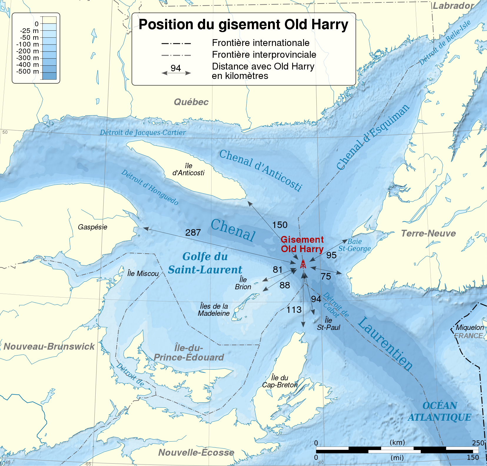
English: Location map of Old Harry oil field in the Saint Lawrence Gulf. The exact location of the field is 48.0514706 N, 60.3942736 W. Cartographic data :
Français : Carte montrant l'emplacement du gisement Old Harry dans le golfe du Saint-Laurent, et les distances le séparant des terres voisines. Le gisement se trouve exactement aux coordonnées 48.0514706 N, 60.3942736 O. Données cartographiques :
|
||
| Date | (UTC) | ||
| Source |
This file was derived from: Golfe Saint-Laurent Depths fr.svg: |
||
| Author | Sémhur (talk) | ||
| Other versions | |||
| Attribution (required by the license) | © Sémhur / Wikimedia Commons / | ||
| SVG | W3C-validity not checked.
|
||
| Graphic Lab |

| Camera location | | View this and other nearby images on: OpenStreetMap |
|---|
Licensing
edit
I, the copyright holder of this work, hereby publish it under the following licenses:
This file is licensed under the Creative Commons Attribution-Share Alike Attribution-Share Alike 4.0 International, 3.0 Unported, 2.5 Generic, 2.0 Generic and 1.0 Generic license.
- You are free:
- to share – to copy, distribute and transmit the work
- to remix – to adapt the work
- Under the following conditions:
- attribution – You must give appropriate credit, provide a link to the license, and indicate if changes were made. You may do so in any reasonable manner, but not in any way that suggests the licensor endorses you or your use.
- share alike – If you remix, transform, or build upon the material, you must distribute your contributions under the same or compatible license as the original.
| Copyleft: This work of art is free; you can redistribute it and/or modify it according to terms of the Free Art License. You will find a specimen of this license on the Copyleft Attitude site as well as on other sites. |
You may select the license of your choice.
Original upload log
edit
This image is a derivative work of the following images:
- File:Golfe_Saint-Laurent_Depths_fr.svg licensed with Cc-by-sa-3.0, GFDL
Uploaded with derivativeFX
File history
Click on a date/time to view the file as it appeared at that time.
| Date/Time | Thumbnail | Dimensions | User | Comment | |
|---|---|---|---|---|---|
| current | 09:31, 28 May 2014 | | 1,655 × 1,582 (3.04 MB) | Sémhur (talk | contribs) | Valid SVG |
| 10:47, 21 March 2012 |  | 1,655 × 1,582 (3.04 MB) | Sémhur (talk | contribs) | == {{int:filedesc}} == {{Information |Description={{Multilingual description |en= Location map of Old Harry oild field in the Saint Lawrence Gulf. The exact location of the field is 48.0514706 N, 60.3942736 W.<br> Cartogra... |
You cannot overwrite this file.
File usage on Commons
The following 2 pages use this file:
File usage on other wikis
The following other wikis use this file:
- Usage on en.wikipedia.org
- Usage on fr.wikipedia.org
- Usage on www.wikidata.org