File:Old Lovejoy viaduct viewed from 10th Ave ramp on 7-31-99.jpg

Size of this preview: 800 × 570 pixels. Other resolutions: 320 × 228 pixels | 640 × 456 pixels | 1,024 × 730 pixels | 1,280 × 912 pixels | 2,560 × 1,824 pixels | 3,240 × 2,309 pixels.
Original file (3,240 × 2,309 pixels, file size: 1.98 MB, MIME type: image/jpeg)
Captions
Captions
Add a one-line explanation of what this file represents
Summary edit
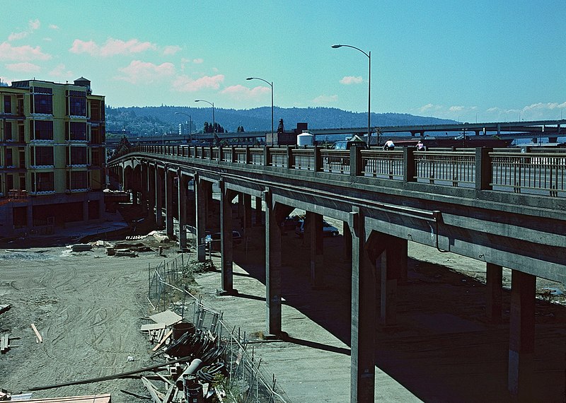
| Description | The old "Lovejoy Ramp" (which was really more of a viaduct) that connected NW 14th Avenue with the Broadway Bridge, in Portland, Oregon. It was closed on the morning of August 1, 1999 (less than 24 hours after the photo was taken) and demolished over the following months, its easternmost section (out of view here) rebuilt as a shorter ramp between 9th Avenue and the bridge. The photo is looking northwest and was taken from a connecting viaduct/ramp on 10th Avenue, which closed at the same time and was also demolished. The Lovejoy viaduct (built in 1927–28) originally carried the street over a large rail yard, but the yard was abandoned in the mid-1990s, to be replaced by dense residential development – some of the earliest of which can be seen at left (at what will be the intersection of 11th & Lovejoy). Lovejoy Street still exists at this location, but not elevated. |
| Date | |
| Source | Own work |
| Author | Steve Morgan |
| Permission (Reusing this file) |
See below; user must attribute the photographer on any reuse. |
|
The architectural work depicted in this photograph may be covered under United States copyright law (17 USC 120(a)), which states that architectural works completed after December 1, 1990 are protected. However, architectural copyright in the United States does not include the right to prevent the making, distributing, or public display of pictures, paintings, photographs, or other pictorial representations of the work. See COM:CRT/United States#Freedom of panorama for more information.

|
| Camera location | | View this and other nearby images on: OpenStreetMap |
|---|
Licensing edit
I, the copyright holder of this work, hereby publish it under the following licenses:
This file is licensed under the Creative Commons Attribution-Share Alike 3.0 Unported license.
- You are free:
- to share – to copy, distribute and transmit the work
- to remix – to adapt the work
- Under the following conditions:
- attribution – You must give appropriate credit, provide a link to the license, and indicate if changes were made. You may do so in any reasonable manner, but not in any way that suggests the licensor endorses you or your use.
- share alike – If you remix, transform, or build upon the material, you must distribute your contributions under the same or compatible license as the original.

|
Permission is granted to copy, distribute and/or modify this document under the terms of the GNU Free Documentation License, Version 1.2 or any later version published by the Free Software Foundation; with no Invariant Sections, no Front-Cover Texts, and no Back-Cover Texts. A copy of the license is included in the section entitled GNU Free Documentation License. |
You may select the license of your choice.
File history
Click on a date/time to view the file as it appeared at that time.
| Date/Time | Thumbnail | Dimensions | User | Comment | |
|---|---|---|---|---|---|
| current | 12:13, 8 December 2014 | | 3,240 × 2,309 (1.98 MB) | Steve Morgan (talk | contribs) | adjusted color slightly |
| 09:27, 8 December 2014 |  | 3,240 × 2,309 (1.99 MB) | Steve Morgan (talk | contribs) | {{Information |Description=The old "Lovejoy Ramp" (which was really more of a viaduct) that connected NW 14th Avenue with the Broadway Bridge, in Portland, Oregon. It was closed on the morning of August 1, 1999 (less than 24 hours after the photo was... |
You cannot overwrite this file.
File usage on Commons
The following page uses this file:
File usage on other wikis
The following other wikis use this file:
- Usage on en.wikipedia.org
- Usage on fr.wikipedia.org