File:Ontario-Adirondacks derecho July 14-15 1995.jpg
No higher resolution available.
Ontario-Adirondacks_derecho_July_14-15_1995.jpg (600 × 355 pixels, file size: 33 KB, MIME type: image/jpeg)
Captions
Captions
Add a one-line explanation of what this file represents
Summary edit
| Description |
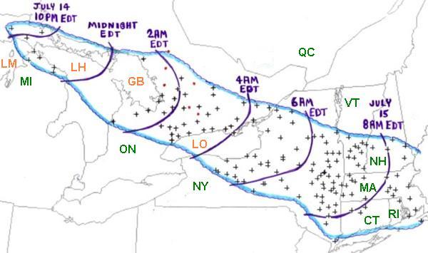
English: Map of the Ontario-Adirondacks derecho, July 14-15 1995 |
| Source | (original: (courtesy of NOAA) [1]) |
| Author |
Licensing edit
This image is in the public domain because it contains materials that originally came from the U.S. National Oceanic and Atmospheric Administration, taken or made as part of an employee's official duties.
|
Original upload log edit
Transferred from en.wikipedia to Commons by The Bushranger using CommonsHelper.
The original description page was here. All following user names refer to en.wikipedia.
- 2007-03-19 00:56 JForget 600×355× (33695 bytes) Map of the Ontario-Adirondacks derecho (courtesy of NOAA) Source: http://www.spc.noaa.gov/misc/AbtDerechos/casepages/jul1995derechopage.htm
File history
Click on a date/time to view the file as it appeared at that time.
| Date/Time | Thumbnail | Dimensions | User | Comment | |
|---|---|---|---|---|---|
| current | 04:57, 2 January 2012 | | 600 × 355 (33 KB) | File Upload Bot (Magnus Manske) (talk | contribs) | {{BotMoveToCommons|en.wikipedia|year={{subst:CURRENTYEAR}}|month={{subst:CURRENTMONTHNAME}}|day={{subst:CURRENTDAY}}}} {{Information |Description={{en|Map of the Ontario-Adirondacks derecho (courtesy of NOAA) Source: http://www.spc.noaa.gov/misc/AbtDerec |
You cannot overwrite this file.
File usage on Commons
The following page uses this file:
- File:1995jul15rpts.jpg (file redirect)
File usage on other wikis
The following other wikis use this file:
- Usage on en.wikipedia.org