File:Opana Radar Original Plot Dec 7, 1941.jpg
Size of this preview: 412 × 600 pixels. Other resolutions: 165 × 240 pixels | 329 × 480 pixels | 527 × 768 pixels | 703 × 1,024 pixels | 1,406 × 2,048 pixels | 2,841 × 4,137 pixels.
Original file (2,841 × 4,137 pixels, file size: 3.91 MB, MIME type: image/jpeg)
Captions
Captions
Add a one-line explanation of what this file represents
Summary
edit
| Description |
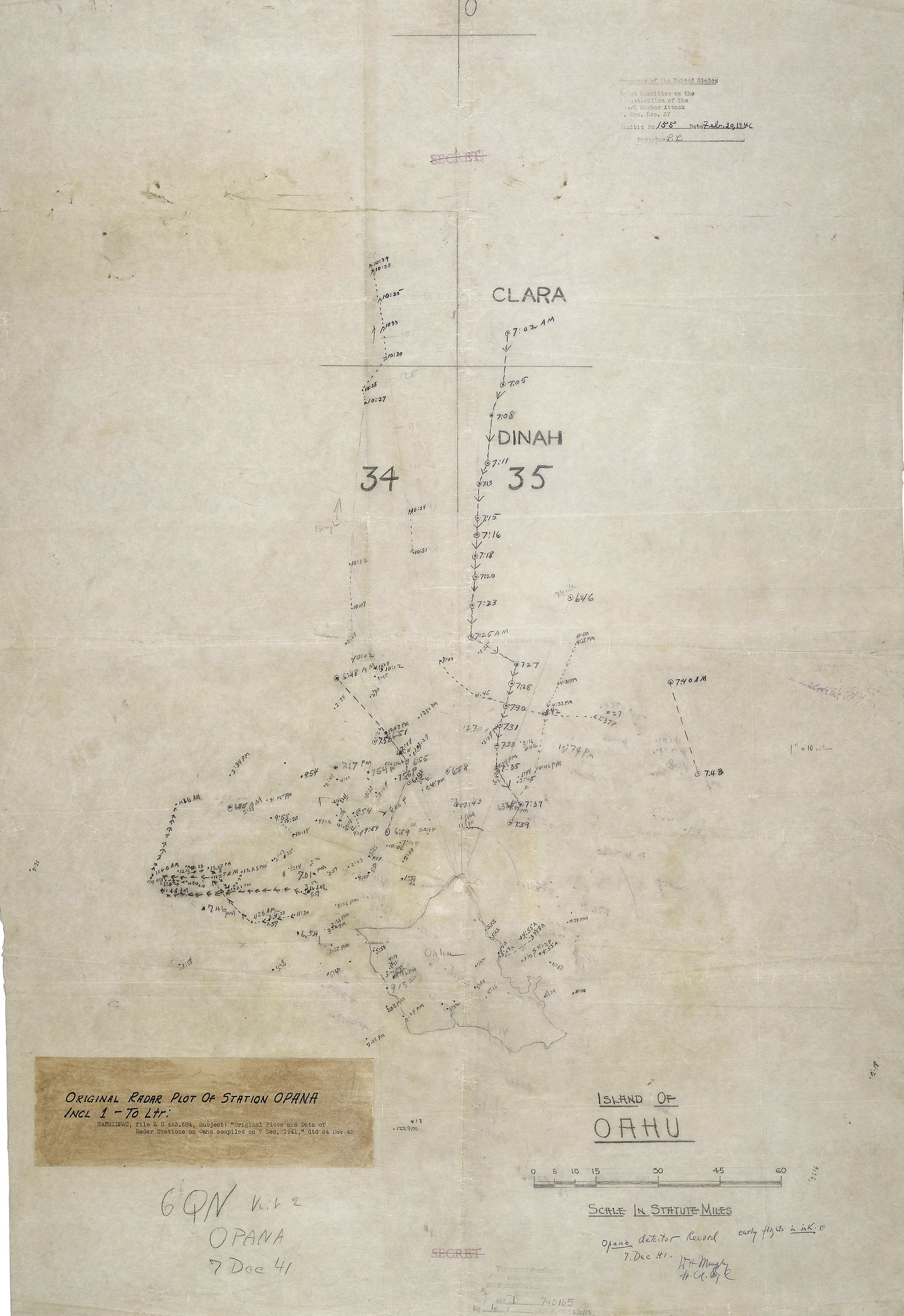
English: Original radar plot from the morning of December 7, 1941, showing track of Japanese planes en route to attack Pearl Harbor. Created at the w:SCR-270 radar site at Opana, on the northern tip of Oahu, Hawaii. |
| Date | |
| Source | https://www.nps.gov/valr/learn/historyculture/opana-mobile-radar-site.htm |
| Author | US Army Privates Joseph Lockard and George Elliott, plus others |
Licensing
edit
This file is a work of a U.S. Army soldier or employee, taken or made as part of that person's official duties. As a work of the U.S. federal government, it is in the public domain in the United States.
|
 |
File history
Click on a date/time to view the file as it appeared at that time.
| Date/Time | Thumbnail | Dimensions | User | Comment | |
|---|---|---|---|---|---|
| current | 20:05, 2 April 2018 | | 2,841 × 4,137 (3.91 MB) | ArnoldReinhold (talk | contribs) | {{Information |description ={{en|1=Original radar plot from the morning of December 7, 1941, showing track of Japanese planes en route to attack Pearl Harbor. Created at the w:SCR-270 radar site at Opana, on the northern tip of Oahu, Hawaii.}} |source =https://www.nps.gov/valr/learn/historyculture/opana-mobile-radar-site.htm |author =US Army Privates Joseph Lockard and George Elliott, plus others |date =1941-12-7 }} Category:Pearl Harbor attack - maps [[Categ... |
You cannot overwrite this file.
File usage on Commons
The following 6 pages use this file:
- User:Chumwa/OgreBot/Potential transport maps/2018 April 1-10
- User:Chumwa/OgreBot/Transport Maps/2018 April 1-10
- User:Chumwa/OgreBot/Travel and communication maps/2018 April 1-10
- User:Holly Cheng/Recent uploads/Hawaii/2018 April 2
- User:Magog the Ogre/Maps of conflicts/2018 April
- Commons:WikiProject Aviation/recent uploads/2018 April 2
File usage on other wikis
The following other wikis use this file:
- Usage on en.wikipedia.org