File:Ordnance Survey Drawings - Pwllheli (OSD 300).jpg

Size of this preview: 800 × 571 pixels. Other resolutions: 320 × 228 pixels | 640 × 457 pixels | 1,024 × 731 pixels | 1,280 × 913 pixels | 2,560 × 1,827 pixels | 4,000 × 2,854 pixels.
Original file (4,000 × 2,854 pixels, file size: 3.54 MB, MIME type: image/jpeg)
Captions
Captions
Add a one-line explanation of what this file represents
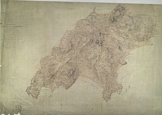
| Pwllheli (OSD 300)
|
|||||
|---|---|---|---|---|---|
| Artist |
Dawson, Robert - Draughtsman |
.jpg) | |||
| Title |
Ordnance Survey Drawings: Pwllheli (OSD 300) |
||||
| Object type |
manuscript map |
||||
| Description |
 Centre of map shown on a map of England
English: This is a plan,of a coastal section of the Lleyn Peninsula in,Wales., The numerical annotations, or spot heights, shown in red ink at the top of hills and eminences,are trigonometrically tested altitudes. This drawing is formally titled and the area of the land recorded,as 100.8 square miles. The manuscript paper carries a watermark from the James Whatman Turkey Mill, Kent, dated 1814..
This image has been georeferenced.
|
||||
| Language |
English |
||||
| Date | 1816 | ||||
| Medium | Pen and ink on paper | ||||
| Dimensions | height: 310 mm (12.20 in); width: 430 mm (16.92 in) | ||||
| Collection | |||||
| Accession number |
Maps OSD 300 |
||||
| Credit line | British Library | ||||
| Notes |
Scale 2 inches : 1 mile (1:31680). Please note that the British Library provides these digital files "as-is"; materials will not be rephotographed under this programme. If resupply of files is required, the requestor will be required to purchase them at the standard rate. |
||||
| References |
http://www.bl.uk/onlinegallery/onlineex/ordsurvdraw/p/002osd000000013u00300000.html (English) |
||||
| Source/Photographer |
|
||||
| Permission (Reusing this file) |
|
||||


_(St_Edwards_Crown).svg)
.jpg¶ms=52.852824_N_-4.60426_E_)
.jpg¶ms=52.746154_N_-4.849194_E_)
.jpg¶ms=52.959494_N_-4.359327_E_)
.jpg¶ms=52.959494_N_-4.84544_E_)
.jpg¶ms=52.749016_N_-4.849194_E_)
.jpg¶ms=52.746154_N_-4.363081_E_)
.jpg¶ms=52.956632_N_-4.359327_E_)
File history
Click on a date/time to view the file as it appeared at that time.
| Date/Time | Thumbnail | Dimensions | User | Comment | |
|---|---|---|---|---|---|
| current | 18:18, 26 September 2013 | | 4,000 × 2,854 (3.54 MB) | LibraryBot (talk | contribs) | {{subst:User:Andrew Gray/OSD|ID= 002OSD000000013U00300000 |OSD_NUM= OSD 300 |MEDIUM= Pen and ink on paper |TITLE= Pwllheli |CREATOR= Dawson, Robert - Draughtsman |YEAR= 1816 |DESCRIPTION= This is a plan,of a coastal section of the Lleyn Peninsula in,Wa... |
You cannot overwrite this file.
File usage on Commons
The following page uses this file:
File usage on other wikis
The following other wikis use this file:
- Usage on www.wikidata.org
.jpg&oldid=713428477)