File:Ordnance Survey Drawings - Salisbury (OSD 76).jpg

Size of this preview: 427 × 600 pixels. Other resolutions: 171 × 240 pixels | 342 × 480 pixels | 547 × 768 pixels | 729 × 1,024 pixels | 1,459 × 2,048 pixels | 2,849 × 4,000 pixels.
Original file (2,849 × 4,000 pixels, file size: 4.74 MB, MIME type: image/jpeg)
Captions
Captions
Add a one-line explanation of what this file represents
| Salisbury (OSD 76)
|
|||||
|---|---|---|---|---|---|
| Artist |
[Crocker, Edmund] - Draughtsman |
.jpg) | |||
| Title |
Ordnance Survey Drawings: Salisbury (OSD 76) |
||||
| Object type |
manuscript map |
||||
| Description |
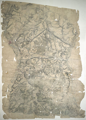
 Centre of map shown on a map of England
English: This drawing is rich in archaeological sites, among them the prehistoric monument known as Stonehenge. Situated on Salisbury Plain, it is the most celebrated megaithic monument in England. The iron-age hillfort of Old Sarum is also marked. A castle and cathedral were built on its earthworks during the 12th century, but abandoned when a new cathedral was built a mile and a half away - the foundation of the modern city of Salisbury. The red line extending from Old Sarum to Beacon Hill is the baseline for the triangulation of the area. Several other archaeological sites are marked: the iron-age hillforts at Vispasians Camp, Ogbury Camp and Clorus's Camp..
This image has been georeferenced.
|
||||
| Language |
English |
||||
| Date | 1807 | ||||
| Medium | Pen and ink on paper | ||||
| Dimensions | height: 490 mm (19.29 in); width: 360 mm (14.17 in) | ||||
| Collection | |||||
| Accession number |
Maps OSD 76 |
||||
| Credit line | British Library | ||||
| Notes |
Scale 2 inches : 1 mile (1:31680). Please note that the British Library provides these digital files "as-is"; materials will not be rephotographed under this programme. If resupply of files is required, the requestor will be required to purchase them at the standard rate. |
||||
| References |
http://www.bl.uk/onlinegallery/onlineex/ordsurvdraw/s/002osd000000019u00052000.html (English) |
||||
| Source/Photographer |
|
||||
| Permission (Reusing this file) |
|
||||


_(St_Edwards_Crown).svg)
.jpg¶ms=51.027655_N_-1.639647_E_)
.jpg¶ms=50.844265_N_-1.858225_E_)
.jpg¶ms=51.211046_N_-1.421068_E_)
.jpg¶ms=51.187227_N_-1.858225_E_)
.jpg¶ms=50.844265_N_-1.804798_E_)
.jpg¶ms=50.868084_N_-1.421068_E_)
.jpg¶ms=51.211046_N_-1.474496_E_)
File history
Click on a date/time to view the file as it appeared at that time.
| Date/Time | Thumbnail | Dimensions | User | Comment | |
|---|---|---|---|---|---|
| current | 21:50, 27 September 2013 | | 2,849 × 4,000 (4.74 MB) | LibraryBot (talk | contribs) | {{subst:User:Andrew Gray/OSD|ID= 002OSD000000019U00052000 |OSD_NUM= OSD 76 |MEDIUM= Pen and ink on paper |TITLE= Salisbury |CREATOR= [Crocker, Edmund] - Draughtsman |YEAR= 1807 |DESCRIPTION= This drawing is rich in archaeological sites, among them the... |
You cannot overwrite this file.
File usage on Commons
The following page uses this file:
File usage on other wikis
The following other wikis use this file:
- Usage on www.wikidata.org
.jpg&oldid=713428731)