File:Oregon 2010 Measures 66 and 67.svg

Size of this PNG preview of this SVG file: 455 × 340 pixels. Other resolutions: 320 × 239 pixels | 640 × 478 pixels | 1,024 × 765 pixels | 1,280 × 956 pixels | 2,560 × 1,913 pixels.
Original file (SVG file, nominally 455 × 340 pixels, file size: 690 KB)
Captions
Captions
Add a one-line explanation of what this file represents
Summary
edit
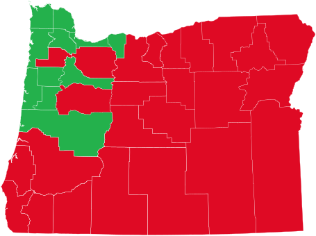
| Description | Results of Oregon Ballot Measures 66 and 67 by county; as the two measures had the counties vote the same way, only one map is needed. |
| Date | |
| Source | Map based on File:Blank Map of Oregon.svg, data from Oregon Secretary of State |
| Author | Mr. Matté (if there is an issue with this image, contact me using this image's Commons talk page, my Commons user talk page, or my English Wikipedia user talk page; I'll know about it a lot faster) |
Licensing
edit
| I, the copyright holder of this work, release this work into the public domain. This applies worldwide. In some countries this may not be legally possible; if so: I grant anyone the right to use this work for any purpose, without any conditions, unless such conditions are required by law. |
File history
Click on a date/time to view the file as it appeared at that time.
| Date/Time | Thumbnail | Dimensions | User | Comment | |
|---|---|---|---|---|---|
| current | 18:23, 31 December 2011 | | 455 × 340 (690 KB) | Mr. Matté (talk | contribs) | {{Information |Description=Results of Oregon Ballot Measures 66 and 67 by county; as the two measures had the counties vote the same way, only one map is needed. |Source=Map based on [[:File:Blank Map of Ore |
You cannot overwrite this file.
File usage on Commons
There are no pages that use this file.
File usage on other wikis
The following other wikis use this file:
- Usage on en.wikipedia.org