File:Oslo local trains SVG map.svg

Size of this PNG preview of this SVG file: 789 × 599 pixels. Other resolutions: 316 × 240 pixels | 632 × 480 pixels | 1,011 × 768 pixels | 1,280 × 972 pixels | 2,560 × 1,945 pixels | 1,772 × 1,346 pixels.
Original file (SVG file, nominally 1,772 × 1,346 pixels, file size: 199 KB)
Captions
Captions
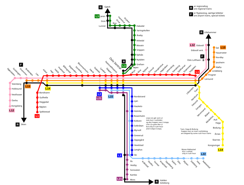
Map over the Oslo local train network with indication of regional trains within this area
Summary edit
| Description |
English: Map of the Oslo local train network with indication of regional trains within this area |
| Date | |
| Source | Own work |
| Author | Bengt Larsson |
Licensing edit
I, the copyright holder of this work, hereby publish it under the following license:
This file is licensed under the Creative Commons Attribution-Share Alike 4.0 International license.
- You are free:
- to share – to copy, distribute and transmit the work
- to remix – to adapt the work
- Under the following conditions:
- attribution – You must give appropriate credit, provide a link to the license, and indicate if changes were made. You may do so in any reasonable manner, but not in any way that suggests the licensor endorses you or your use.
- share alike – If you remix, transform, or build upon the material, you must distribute your contributions under the same or compatible license as the original.
File history
Click on a date/time to view the file as it appeared at that time.
| Date/Time | Thumbnail | Dimensions | User | Comment | |
|---|---|---|---|---|---|
| current | 21:09, 21 January 2022 | | 1,772 × 1,346 (199 KB) | BIL (talk | contribs) | Tried to fix some text problems |
| 20:18, 21 January 2022 |  | 1,772 × 1,346 (196 KB) | BIL (talk | contribs) | Fixed the airport symbol and a spell fix | |
| 18:23, 20 January 2022 |  | 1,772 × 1,346 (194 KB) | BIL (talk | contribs) | Uploaded own work with UploadWizard |
You cannot overwrite this file.
File usage on Commons
The following 2 pages use this file: