File:Osterreich-Ungarn.jpg

Size of this preview: 789 × 600 pixels. Other resolutions: 316 × 240 pixels | 632 × 480 pixels | 1,011 × 768 pixels | 1,280 × 973 pixels | 2,560 × 1,945 pixels | 6,461 × 4,910 pixels.
Original file (6,461 × 4,910 pixels, file size: 15.36 MB, MIME type: image/jpeg)
Captions
Captions
Add a one-line explanation of what this file represents
Summary
edit
| Description |
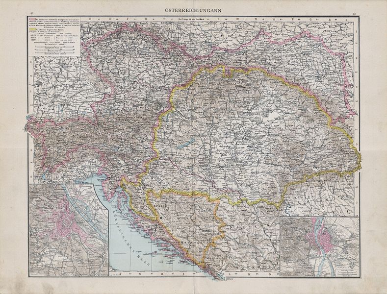
English: map of Austria-Hungary
Slovenčina: mapa Rakúsko-Uhorska |
| Date | |
| Source | Andrees Allgemeiner Handatlas, 1890 |
| Author | Richard Andree |
Licensing
edit
|
This work is in the public domain in its country of origin and other countries and areas where the copyright term is the author's life plus 100 years or fewer. This work is in the public domain in the United States because it was published (or registered with the U.S. Copyright Office) before January 1, 1929. | |
| This file has been identified as being free of known restrictions under copyright law, including all related and neighboring rights. | |
File history
Click on a date/time to view the file as it appeared at that time.
| Date/Time | Thumbnail | Dimensions | User | Comment | |
|---|---|---|---|---|---|
| current | 13:11, 7 July 2008 | | 6,461 × 4,910 (15.36 MB) | Matriosa (talk | contribs) | {{Information |Description={{en|1=map of Austria-Hungary}} {{sk|1=mapa Rakúsko-Uhorska}} |Source=Allgemeiner handatlas. 1890 |Author=Andree |Date=1890 |Permission= |other_versions= }} {{ImageUpload|full}} Category:Old maps of Austria-Hungary |
You cannot overwrite this file.
File usage on Commons
The following 2 pages use this file:
File usage on other wikis
The following other wikis use this file:
- Usage on de.wikiversity.org
- Usage on sk.wikipedia.org