File:Osterseen Position.png

Size of this preview: 465 × 599 pixels. Other resolutions: 186 × 240 pixels | 373 × 480 pixels | 834 × 1,074 pixels.
Original file (834 × 1,074 pixels, file size: 208 KB, MIME type: image/png)
Captions
Captions
Add a one-line explanation of what this file represents
Summary edit
| Description |
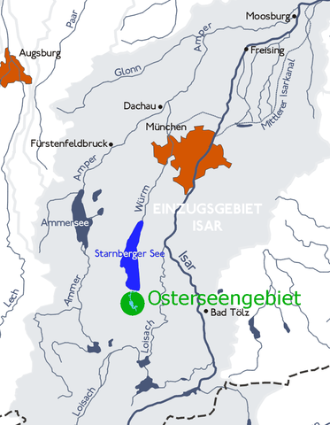
English: Osterseen, Upper Bavaria, Germany: Position. Deutsch: Positionskarte der Osterseen im Einzugsgebiet der Isar |
||||||||
| Date | 26 June 2005 (upload date) | ||||||||
| Source |
Own work based on: Karte einzugsbereich ohne hydrol Grenzen.png Original text: GFDL-Map from de.wikipedia, adapted by myself: Dominik Hundhammer, June 2005. |
||||||||
| Author | Dominik Hundhammer | ||||||||
| Permission (Reusing this file) |
|

File history
Click on a date/time to view the file as it appeared at that time.
| Date/Time | Thumbnail | Dimensions | User | Comment | |
|---|---|---|---|---|---|
| current | 08:39, 26 June 2005 | | 834 × 1,074 (208 KB) | Zerohund~commonswiki (talk | contribs) | Osterseen, Upper Bavaria, Germany: Position. GFDL-Map from de.wikipedia, adapted by myself: Dominik Hundhammer, June 2005. {{GFDL}} |
You cannot overwrite this file.
File usage on Commons
The following page uses this file:
File usage on other wikis
The following other wikis use this file: