File:Ostpreussen LK Elbing.PNG

Size of this preview: 557 × 600 pixels. Other resolutions: 223 × 240 pixels | 446 × 480 pixels | 713 × 768 pixels | 951 × 1,024 pixels | 1,772 × 1,908 pixels.
Original file (1,772 × 1,908 pixels, file size: 9.69 MB, MIME type: image/png)
Captions
Captions
Add a one-line explanation of what this file represents
Summary edit
| Description |
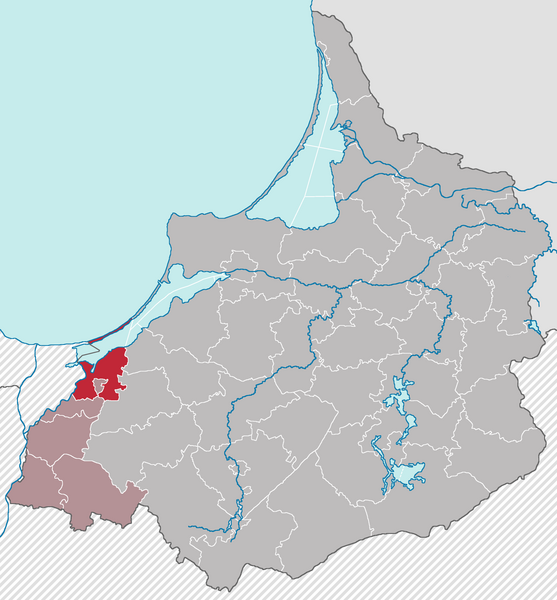
English: Locator map of Landkreis Elbing in East Prussia with Borders of 31.08.1939 and administrative divisions of January 1945 Deutsch: Lage des Landkreises Elbing in Ostpreußen in den Grenzen vom 31.08.1939 und der Verwaltungsgliederung vom Januar 1945 |
| Date | |
| Source | Own work |
| Author | Niedersachse66 |
Licensing edit
I, the copyright holder of this work, hereby publish it under the following license:
This file is licensed under the Creative Commons Attribution-Share Alike 3.0 Unported license.
- You are free:
- to share – to copy, distribute and transmit the work
- to remix – to adapt the work
- Under the following conditions:
- attribution – You must give appropriate credit, provide a link to the license, and indicate if changes were made. You may do so in any reasonable manner, but not in any way that suggests the licensor endorses you or your use.
- share alike – If you remix, transform, or build upon the material, you must distribute your contributions under the same or compatible license as the original.
File history
Click on a date/time to view the file as it appeared at that time.
| Date/Time | Thumbnail | Dimensions | User | Comment | |
|---|---|---|---|---|---|
| current | 16:21, 29 November 2012 | | 1,772 × 1,908 (9.69 MB) | Niedersachse66 (talk | contribs) | User created page with UploadWizard |
You cannot overwrite this file.
File usage on Commons
There are no pages that use this file.
File usage on other wikis
The following other wikis use this file:
- Usage on de.wikipedia.org