File:Ota-waju.jpg

Size of this preview: 414 × 599 pixels. Other resolutions: 166 × 240 pixels | 332 × 480 pixels | 531 × 768 pixels | 707 × 1,024 pixels | 1,624 × 2,350 pixels.
Original file (1,624 × 2,350 pixels, file size: 876 KB, MIME type: image/jpeg)
Captions
Captions
Add a one-line explanation of what this file represents
Summary edit
| Description |
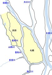
日本語: 太田輪中・七郷輪中と周囲の状況。黒線は主要な堤防、黒字は輪中の名称。水色線・青字は主要な河川。国土交通省中部地方整備局『堤防変遷図』、およびGoogleMAPや埼玉大学教育学部谷謙二『今昔マップ on the web』を参考に作成。 |
| Date | |
| Source | Own work |
| Author | アセルス |
Licensing edit
I, the copyright holder of this work, hereby publish it under the following license:
This file is licensed under the Creative Commons Attribution-Share Alike 4.0 International license.
- You are free:
- to share – to copy, distribute and transmit the work
- to remix – to adapt the work
- Under the following conditions:
- attribution – You must give appropriate credit, provide a link to the license, and indicate if changes were made. You may do so in any reasonable manner, but not in any way that suggests the licensor endorses you or your use.
- share alike – If you remix, transform, or build upon the material, you must distribute your contributions under the same or compatible license as the original.
File history
Click on a date/time to view the file as it appeared at that time.
| Date/Time | Thumbnail | Dimensions | User | Comment | |
|---|---|---|---|---|---|
| current | 03:17, 5 April 2024 | | 1,624 × 2,350 (876 KB) | アセルス (talk | contribs) | 対岸堤防の追加 |
| 01:37, 21 March 2024 |  | 1,624 × 2,350 (756 KB) | アセルス (talk | contribs) | 輪中の形状を修正して作り直し | |
| 07:17, 19 April 2023 |  | 1,624 × 2,350 (735 KB) | アセルス (talk | contribs) | 綺麗に作り直し | |
| 03:36, 30 August 2022 |  | 794 × 1,117 (263 KB) | アセルス (talk | contribs) | 長除川を追加 | |
| 01:14, 30 August 2022 |  | 794 × 1,117 (257 KB) | アセルス (talk | contribs) | Uploaded own work with UploadWizard |
You cannot overwrite this file.
File usage on Commons
There are no pages that use this file.